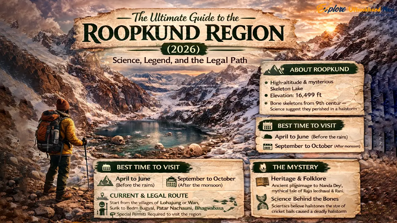
India’s most scientifically contested and spiritually charged trek — fully updated for legal compliance in 2026 At 15,700 feet, there is a lake that should not exist. The glacial bowl of Roopkund fills and empties with the seasons, and when its waters recede in September, they reveal something that has baffled scientists, unsettled archaeologists, and confirmed every legend the Garhwali hill people ever told: hundreds of human skeletons, lying exposed on the rock and shingle as though they simply lay down to rest. But rest is not what happened here. This is the definitive 2026 guide to the Roopkund region — one that respects both the science and the legend, explains the legal reality of trekking here today, and gives you the tools to do it responsibly. We have deliberately built this to replace every outdated, legally inaccurate, and ecologically irresponsible guide that still dominates search results. Read this, and then go — the right way. — WHY THIS TREK — Why Roopkund Remains the Everest of Indian Trekking Beyond the Skeletons: High-Altitude Meadows and Glacial Mysteries The skeletons are the headline, but they are not the whole story. The Roopkund trail is, by any measure, one of the most visually spectacular high-altitude routes in India. The approach through Ali and Bedni Bugyals — vast, undulating meadows at nearly 12,000 feet — offers panoramic views of the Trishul massif (7,120 m) and Nanda Ghunti (6,309 m) that arrive with the abruptness of a revelation. One moment you are in oak and rhododendron forest; the next, the hillside simply opens, and there is the entire western Kumaon Himalaya, ranged across the northern horizon like a sentence that ends in an exclamation mark. Higher up, the terrain shifts again. The rock shelters at Bhagwabasa (14,100 ft) have an eerie, end-of-the-world quality — the stone is dark basalt and schist, the wind is constant, and the silence between gusts feels thick enough to touch. This is a place that demands your full physiological and psychological attention. The lake itself, when the snow and meltwater recede in late September and October to reveal the bones, is smaller than most people imagine — roughly 40 metres across — but carries the gravitational weight of a much larger monument. The 2026 Perspective: Why Roopkund Is No Longer ‘Beginner-Friendly’ For years, commercial trekking companies marketed Roopkund as a ‘moderate’ or even ‘beginner’ trek. That categorisation was always optimistic; in 2026 it is simply inaccurate. The logistical changes introduced by the Uttarakhand government — specifically the elimination of meadow camping and the shift to village-based accommodation — have added distance, gained elevation, and required greater self-sufficiency from trekkers. This is now a demanding, multi-day high-altitude route that requires genuine physical preparation and a minimum of two or three prior Himalayan treks at 10,000+ feet. If you are new to Himalayan trekking and are looking for a high-altitude introduction, we strongly recommend starting with the Chopta Tungnath Chandrashila Trek — it offers comparable panoramic rewards at 13,100 feet with a fraction of the logistical complexity. Come back to Roopkund when your lungs know what 14,000 feet feels like. — LEGAL REALITY — The 2026 Legal Status: Navigating the ‘Bugyal’ Ban The High Court Ruling: A Transparent Look at the Camping Ban In 2018, the Uttarakhand High Court issued a landmark ruling restricting overnight camping on the alpine meadows — bugyals — of the state, specifically citing Ali Bugyal and Bedni Bugyal in the Roopkund region. The ruling was not a ban on trekking; it was a ban on camping on the grass itself. The ecological rationale was clear: decades of commercial trekking had degraded the fragile, soil-thin turf of these meadows through tent pegs, open fires, and human waste. The bugyals are among the most ecologically sensitive grassland ecosystems in the Indian Himalaya, and they were being destroyed. Legal Status (2026): Trekking through Ali and Bedni Bugyals is fully permitted during the open season (approximately May–June and September–November). What is banned: Overnight camping on the meadow grass. Pitching tents on the bugyal turf, open fires, and unmanaged waste disposal. What is legal: Day hiking across the meadows, trekking through them en route to higher destinations, and staying in designated forest-fringe campsites at the edges of the meadows. How We Trek Today: Village Homestays and Forest-Fringe Campsites The practical result of the ban is that the modern Roopkund trek is more culturally rich and logistically honest than its pre-ban incarnation. Trekkers now base themselves in Didna village (on the approach) and Wan village (on the descent) — two Garhwali communities at the edge of the forest that have developed a genuine homestay culture over the past four years. Meals are Garhwali home cooking: thick rotis, dal with mountain herbs, seasonal sabzis, and a glass of warm milk from cattle whose grazing range extends to 10,000 feet. This is not a compromise; it is a fundamentally better experience than sleeping in a commercial tent city on the meadow. Permits & Forest Department Rules: The 2026 Digital System As of 2026, all Roopkund trekkers are required to register through the Uttarakhand Forest Department’s online portal before commencing the trek. The permit counter is physically located at Lohajung basecamp, but completing the digital registration in advance is strongly recommended to avoid queues. Key details: Entry fee: ₹150 per person per day (Indian nationals); ₹600 per person per day (foreign nationals) Group size: Maximum 20 trekkers per registered group Mandatory: Proof of identity, emergency contact details, fitness self-declaration Seasonal window: The forest gate is typically open May 1 – June 15 and September 1 – November 15, subject to weather. Check the Chamoli District Forest Division website for real-time gate status before travel. ⚠ IMPORTANT NOTE Permits cannot be purchased retroactively. Trekkers caught beyond the forest gate without a valid digital permit face fines of ₹2,500–₹10,000 and potential trail bans. Register before you arrive at Lohajung. — THE SCIENCE — Solving the Mystery: The 2019 Science Update vs. Local Lore The DNA Breakthrough:
The Ultimate Kanatal Travel Guide (2026)
India’s most quietly magical Himalayan escape, reimagined for the modern traveller Close your eyes and imagine this: you are sitting on a ridge at 8,200 feet, wrapped in a Garhwali shawl, watching the Milky Way arc across a sky so dark it feels personal. Below you, a sea of deodar pine rolls away into silence. No honking horns. No hawkers. Just the distant tinkle of a cowbell, and the hush of altitude. This is Kanatal — and in 2026, it is still, miraculously, all yours. We have been writing about offbeat Uttarakhand for years, and every time we think Kanatal is about to tip into the mainstream, it surprises us with another layer of quiet. This guide is the most comprehensive we have ever produced — built for the digital nomad who needs a solid Wi-Fi SLA, the adventure seeker who wants snow and adrenaline in the same weekend, the photographer hunting the Milky Way, and the conscious traveller who refuses to leave footprints. Welcome to the cloud forest. Let us go in. — THE DESTINATION — Why Kanatal in 2026? The Unspoiled Himalayan Escape The Shift from Mussoorie: Why Travellers Are Choosing Kanatal’s Silence Mussoorie had its glory days. Mall Road at 6 p.m. on a weekend in October now looks less like a hill-station promenade and more like a metro station at rush hour. The traffic queues on the Kempty Fall road stretch back kilometres. Hotels have multiplied like monsoon mushrooms. And so, quietly, a certain breed of traveller — tired, discerning, allergic to crowds — has been routing 38 kilometres further northeast into the Tehri Garhwal district, to a ridge-top village sitting at 8,500 feet where the air still bites and the horizon still belongs to Bandarpunch and Swargarohini. Kanatal is not a secret. But it is well-behaved. The Uttarakhand government’s eco-zoning restrictions have kept large hotel chains at bay. Most accommodations are small — ten rooms or fewer — and the road that winds up from Chamba is just sinuous enough to discourage casual day-trippers. The result is a place that feels, even in 2026, genuinely unhurried. When you wake up to the sound of nothing but wind through pine needles, you understand immediately why people who come once tend to come back obsessively. “The morning mist doesn’t lift in Kanatal — it performs. It rises slowly from the valley like a curtain, revealing the Himalayan panorama in acts.” What’s New: The Rise of Astro-Tourism and Eco-Glamping Two trends have quietly transformed the Kanatal experience in recent years and reached a tipping point by 2026. The first is astro-tourism — the act of travelling specifically to witness a dark sky. With Delhi’s night sky registered at a Bortle Class 9 (near-total light pollution), the drive of six hours to reach Kanatal’s Bortle Class 3–4 darkness is, for many urban Indians, nothing short of revelatory. Several properties now offer dedicated stargazing decks, red-light torch rentals, and in-house astronomers during peak season (May to September). The second is eco-glamping, which in Kanatal has evolved well beyond the canvas-tent-with-a-mattress phase. Think: precision-engineered geodesic domes with panoramic acrylic skylights, composting toilets, rainwater harvesting, and in-room wood-fired stoves. Several of these properties have received certification from the Uttarakhand Homestay & Eco-Tourism Board. Booking them months in advance for the October window is now simply non-negotiable. — BEFORE YOU GO — The 2026 Traveller’s Digital & Logistics Checklist Connectivity Check: 5G Availability (Jio/Airtel) and “Dead Zones” in Kodia Jungle The good news first: both Jio and Airtel have expanded 5G coverage along the Chamba–Kanatal main stretch, and most lodges on the primary ridge now report consistent 40–80 Mbps download speeds — more than sufficient for 4K video calls. Step off the main road into the Kodia Jungle trails, however, and you will hit near-complete dead zones within 400 metres. Download your maps and files before you lace up your boots. A local Jio SIM with a 5G pack remains the most reliable solution; Airtel works equally well on the ridge but can be spottier on the Tehri-facing slope. EDITOR’S NOTE Several eco-lodges now offer a dedicated “Work Pod” — a small insulated cabin with a wired ethernet connection and a ring-light, positioned for the best valley view. If remote work is your primary reason for visiting, ask your host about this specifically when booking. EV Charging Stations: Nearest Fast-Chargers There are no fast-chargers in Kanatal village itself as of early 2026. Your nearest options: Tehri Dam area (28 km): Two Tata Power EZ Charge DC fast-chargers (60 kW) at the THDC township. Reliable, 24-hour. Chamba town (14 km): A 22 kW AC charger at the petrol pump on the Rishikesh–Dharasu road. Slower, but convenient for overnight top-ups. Dehradun gateways: Multiple 120 kW+ fast-chargers at the ISBT area and Pacific Mall. Charge up fully before ascending. Rishikesh: Three fast-charger bays near the Triveni Ghat parking area. Ideal if you are coming via the scenic Rishikesh–Chamba route. Pro tip: If you are driving a long-range EV (400+ km range), a full charge from Dehradun will comfortably cover the Kanatal round trip. For shorter-range vehicles, plan a top-up at Chamba on arrival. Permits & Entry: Updated 2026 Guidelines Kanatal itself requires no permit for regular visitors. Two situations where documentation matters: if you are transiting on the Char Dham route during the April–June and September–October pilgrimage seasons, expect checkpoints at Chamba and Dharasu where your vehicle RC and ID are verified. Seasonal forest permits for Kodia Jungle (valid April–June and September–November) cost ₹100 per person and are now available online through the Uttarakhand forest department portal — do this in advance to skip the queue. Cash vs. Digital: Where UPI Works and Why You Need Emergency Cash On the main stretch and at established lodges, UPI (Google Pay, PhonePe, Paytm) works seamlessly. The situation changes once you head toward local hamlets — places like Kotigaon or the lanes of Jwarna village. Here, older shopkeepers and dairy farmers operate exclusively on cash. Carry at least
Dehradun City Guide 2026 Everything to Do, See, and Eat in the City of Joy
Introduction: Welcome to the City of Joy There is a saying among long-time Dehradun residents that the Doon Valley doesn’t just accommodate you — it adopts you. This is a city that has been welcoming people for centuries: pilgrims heading to the hills, scholars drawn to its legendary schools, soldiers on their way to the cantonments, and increasingly, travellers from across India and beyond who arrive for a weekend and find themselves returning again and again. Set in the Doon Valley — a broad, fertile basin formed between the Shivalik Hills to the south and the outer Himalayas to the north — Dehradun occupies one of the most geographically privileged positions in northern India. At approximately 640 metres above sea level, it is warm enough to be pleasant year-round, cool enough in summer to feel like a reprieve from the plains, and close enough to both mountains and rivers to give nature-lovers endless options. Dehradun is known as the “City of Joy” — a nickname that has less to do with marketing and more to do with accumulated character. This is a city built by the convergence of extraordinary institutions (the Indian Military Academy, the Forest Research Institute, the Doon School), ancient spiritual traditions (Guru Ram Rai’s Darbar, Tapkeshwar Temple), and a modern energy fuelled by Uttarakhand’s status as a state capital since 2000. The result is an urban personality unlike anything else in the Himalayan belt: simultaneously academic, military, spiritual, and deeply, authentically liveable. As the state capital of Uttarakhand and the natural gateway to the entire Himalayan region, Dehradun is where most Uttarakhand journeys begin. It is the place you land before the mountains, the city you return to from the high altitudes, and — for those paying attention — a rewarding destination in its own right. History & Mythology: Layers of an Ancient Valley The Dronacharya Connection — Dronanagri Long before it was a cantonment town or a state capital, the Doon Valley was Dronanagri — the legendary home of Dronacharya, the revered preceptor of the Pandavas and Kauravas in the Mahabharata. It is said that Guru Dronacharya chose this valley, between the sacred rivers Ganga and Yamuna, as the site of his gurukul — the forest school where he trained India’s greatest warriors in archery, statecraft, and philosophy. Whether legend or history, this connection gives Dehradun a mythological depth that few Indian cities can claim. The valley’s tradition of guru-shishya education — master and student, knowledge passed in forest settings — echoes through its modern identity as India’s most celebrated centre of residential schooling. The ancient gurukul and the Doon School are, in their own ways, the same idea separated by three thousand years. Guru Ram Rai and the Origin of ‘Dehra-Dun’ The city’s modern name is rooted in Sikh history. In 1675, Guru Ram Rai — the eldest son of Guru Har Rai, the seventh Sikh Guru — arrived in the valley after a complex political episode at the Mughal court. Guru Har Rai, disapproving of his son’s accommodation of Emperor Aurangzeb, designated his younger son as his successor instead. Guru Ram Rai came to settle in the Doon Valley, establishing a “Dehra” (camp or resting place) that grew into a permanent community. The Darbar Shri Guru Ram Rai Ji — the magnificent Sikh shrine in the heart of Dehradun — remains one of the city’s most important religious sites, and the annual Jhanda Mela (Flag Festival) celebrated here in March is the city’s biggest and most beloved festival. The very name of the city — “Dehra-Dun” — is believed to derive from this settlement: Dehra (camp) + Dun (valley). Dehradun as an Education Hub: Why the City Feels Young Walk through Dehradun on any weekday morning and you will quickly understand why the city has a particular kind of energy that older hill towns do not. This is a young city — not in age, but in spirit — because it has been continuously shaped by institutions that attract and cultivate talent from across India and the world. The Indian Military Academy (IMA) Founded in 1932, the Indian Military Academy is one of India’s most prestigious and consequential institutions — the training ground for generations of Indian Army officers. The IMA’s Chetwode Hall and the passing-out parades that mark each graduating batch are part of Dehradun’s civic identity. The immaculately maintained cantonment area that the IMA anchors gives central Dehradun much of its orderly, wide-avenues character. The Forest Research Institute (FRI) An absolute must-visit for any Dehradun traveller, the Forest Research Institute is one of the finest examples of colonial architecture in India — a vast Greco-Roman complex set in 450 hectares of maintained forest and gardens. Built between 1906 and 1929, the FRI’s main building with its distinctive colonnade, red brick, and manicured lawns looks like it belongs in a British university town and has become one of India’s most photographed institutional buildings. The FRI houses multiple museums covering forestry, soil, fauna, social forestry, and pathology — genuinely interesting even for non-specialists — and the grounds are beautiful for a long morning walk. Entry is free for Indian nationals. Timings: Museums open 9:30 AM – 5:00 PM; closed Sundays and government holidays Tip: Visit on weekday mornings for the best light on the building’s facade and the quietest grounds The Doon School & Welham’s The Doon School, established in 1935, is India’s most storied boarding school — an institution that has produced prime ministers (Rajiv Gandhi), Nobel laureates, business leaders, and public figures out of all proportion to its size. Its red-brick buildings and cricket grounds have become a kind of shorthand for a certain strain of Indian academic aspiration. Welham Girls’ School, its equally prestigious sister institution nearby, completes the picture. These schools are not open to casual visitors, but they shape the city’s character visibly: the café culture, the bookshops, the general intellectual texture of central Dehradun all reflect a city built around the idea that education matters. Top
Pithoragarh Travel Guide Exploring the Little Kashmir of Uttarakhand in 2026
Quick Facts at a Glance 📌 Detail ℹ️ Info 🗓️ Best Time Altitude: 1,814 m District HQ, Kumaon March – June Nearest Railway: Tanakpur (~151 km) Airport: Naini Saini (5 km) Sept – November Distance from Delhi: ~480 km From Almora: ~116 km Avoid: July – August Pithoragarh: The Little Kashmir of the Himalayas There are places that earn their nicknames, and then there are places that deserve them. Pithoragarh — the district headquarters of Uttarakhand’s easternmost district, nestled at 1,814 metres in the Kumaon Himalaya — has been called “Little Kashmir” since travellers first arrived and fell silent at the view. The reason is immediately apparent to anyone who has seen the Soar Valley from the surrounding ridges: a wide, verdant basin cupped by forested hillsides and framed by the snow-mantled peaks of Nanda Devi, Panchachuli, and the Api-Nampa range on the Nepal border. The resemblance to the Dal Lake basin in Kashmir — that specific combination of flat valley floor, surrounding mountains, and luminous light — is not a tourist promotion’s conceit. It is genuinely, startlingly real. But Pithoragarh carries far more than a pretty comparison. It is one of Uttarakhand’s most historically layered towns — ruled by the Chand Kings, contested by the Gorkha empire, and shaped by British administration. It is the last major town before the Kailash Mansarovar Yatra route climbs into the high Himalayas toward Tibet — a fact that gives the town a particular spiritual gravity, as pilgrims and trekkers gather here year after year before journeys into some of the most sacred terrain on Earth. Pithoragarh also sits at the heart of a region rich in hidden places, ancient temples, trekking routes, and a distinctive Kumaoni cultural life that rewards slow, curious travel. Whether you arrive as a pilgrim, an adventurer, a history lover, or simply someone who wants to look at mountains, this Pithoragarh travel guide covers everything you need. For a broader Kumaon context, our ultimate guide to the best hill stations in the Kumaon region will help you build the perfect regional itinerary. Pithoragarh Travel News: 2026 Update Here is the latest Pithoragarh travel news and connectivity update for the 2026 travel season: 📰 PITHORAGARH TRAVEL NEWS — 2026 UPDATE Naini Saini Airport — Improved Connectivity (2026): Naini Saini Airport, just 5 km from town, has seen significant runway and terminal upgrades. As of 2026, improved services connect Pithoragarh with Dehradun and Delhi on select days, dramatically reducing travel time. Always confirm current schedules before travel, as mountain route services are subject to seasonal weather disruptions. Road Conditions (2026 Season): The primary road links via Almora (NH-309A) and via Tanakpur-Champawat have seen resurfacing and improved drainage. Check with local transport authorities before travel between July and September when monsoon rains can cause temporary closures. Kailash Mansarovar Yatra (2026): The Government of India has confirmed phased resumption of the Kailash Mansarovar Yatra via the Lipulekh Pass route for 2026, subject to bilateral arrangements with China. Intending pilgrims should register with the Ministry of External Affairs well in advance. Soar Valley Road Project: Road improvement works in the Soar Valley are ongoing; some detours may be in effect in early 2026. Confirm locally before planning day trips to Chandak or valley viewpoints. The History of Pithoragarh: Empires in the Mountains Pithoragarh’s history is as layered as the geology of the hills surrounding it. The town’s earliest traceable history connects it to the Chand dynasty of Kumaon — the medieval rulers who, from their seat at Champawat and later Almora, shaped the cultural, religious, and administrative landscape of the entire Kumaon region from the 10th to the 18th century. The Chand kings were prolific temple builders and art patrons. Several sacred sites that define Pithoragarh today — including the Mostamanu Temple and traditions surrounding Dhwaj Temple — trace their origins or patronage to the Chand period. In the late 18th century, the Gorkha empire — expanding aggressively from Nepal — absorbed Pithoragarh into its domain (1790–1815). The Gorkha period left distinct marks: the military fortifications later expanded by the British, the Nepali-inflected linguistic patterns still audible in parts of the district, and the cultural interchange that shaped local customs and craft traditions. The Gorkhas were expelled following the Anglo-Nepalese War (1814–16), after which Pithoragarh became part of British India. The colonial administration built the Pithoragarh Fort (London Fort), developed the cantonment, and established the administrative infrastructure that shaped the town’s modern form. Independence in 1947 transferred this legacy to the Indian state, and Pithoragarh today wears all three layers of its history simultaneously — Chand, Gorkha, and British — in its temples, fortifications, and cultural life. Places to See in Pithoragarh Pithoragarh Fort (London Fort) The most iconic structure in Pithoragarh, the Pithoragarh Fort — known locally as the London Fort — dominates the town from its hilltop position above the Soar Valley. Built during the Gorkha occupation and significantly extended by the British, the fort’s weathered stone walls and bastions are a potent symbol of the town’s contested, multilayered past. From the upper ramparts, the full sweep of the Soar Valley is visible — the flat, cultivated basin surrounded by forested ridges, with the distant white profiles of the high Himalaya framing the northern horizon. Best for: History enthusiasts, photography, panoramic Soar Valley views Distance: ~1.5 km from town centre; accessible by short uphill walk or vehicle Chandak Hills — Himalayan Panorama at 2,600 m About 7 km from Pithoragarh town, Chandak Hills rises to approximately 2,600 metres and offers what many consider the finest accessible viewpoint in the entire district. On a clear morning, the panorama encompasses the Panchachuli peaks, the Api-Nampa massif on the Nepal border, and on exceptional days, the white dome of Nanda Devi hovering above the horizon. A government-run guesthouse at the summit makes overnight stays possible, allowing you to catch both sunset and sunrise panoramas in a single visit. Distance: ~7 km; taxi or private vehicle recommended Stay: KMVN guesthouse at Chandak; advance
Chakrata Complete Guide The Ultimate Offbeat Hill Station in Uttarakhand (2026)
Chakrata: India’s Best-Kept Mountain Secret There is a particular thrill that comes from discovering a place that feels like it exists outside the tourist machine — where the pine forest is genuinely quiet, the air is genuinely cold, and you can sit on a ridge at dusk watching the Himalayas turn orange without fighting a crowd for your view. Chakrata is that place. A secluded cantonment town tucked in the Jaunsar-Bawar region of Uttarakhand’s Dehradun district, Chakrata sits at an altitude of 2,118 metres (6,949 ft) on a ridge between the Tons and Yamuna rivers. It is one of the few hill towns in northern India where development has moved slowly enough that the natural landscape still dominates — dense forests of oak, rhododendron, and deodar cedar covering the hillsides, undisturbed waterfalls plunging through pristine gorges, and ancient temples where the priests outnumber the tourists. While the name Chakrata is unfamiliar to many travellers, those in the know have quietly prized it for years. It regularly features among the top offbeat hill stations in India precisely because of what it lacks: the honking taxis, the souvenir clutter, the cable cars to overcrowded viewpoints. What it has instead is something far rarer — genuine, unhurried wilderness within a day’s drive of Delhi. There is one logistical reality to understand before planning your trip: Chakrata is an active military cantonment administered by the Indian Army. This shapes the town’s character in largely positive ways — it is extraordinarily safe, well-maintained, and orderly — but it does mean that non-Indian citizens require a special permit to enter. We cover this in detail later in this guide. This Chakrata travel guide covers everything — from the top 10 places to visit and things to do, to weather, logistics, food, and a full FAQ section. Whether you’re planning a weekend escape from Dehradun or a longer mountain immersion, Chakrata is ready to surprise you. Top 10 Places to Visit in Chakrata Here are the ten experiences that define a complete Chakrata journey — from thundering waterfalls to prehistoric caves to panoramic Himalayan viewpoints. Tiger Falls — The Jewel of the Jungle At 312 feet (approximately 95 metres), Tiger Falls is one of the highest and most spectacular waterfalls in Uttarakhand — and almost certainly the most dramatic single natural feature in the Chakrata region. The waterfall plunges in an unbroken curtain of white water through a narrow, forested gorge, landing in a cold emerald pool surrounded by mossy rocks and cedar trees that block out the sky. The access route is itself part of the experience: a 5-kilometre forest trek from the road end that passes through one of the most beautiful stretches of mixed forest in this part of Uttarakhand. The path is well-marked and manageable for most fitness levels, making Tiger Falls one of Chakrata’s most rewarding outings. For a complete breakdown of the trek route, best visiting conditions, entry details, and what to bring, read our dedicated Tiger Falls essential guide. Distance from Chakrata: ~20–25 km by road + 5 km forest trek Best season: March to June for full flow; avoid monsoon season (July–September) for safety Tip: Start the trek by 8 AM on weekdays to have the falls almost entirely to yourself Budher Caves — Into the Prehistoric Dark One of Chakrata’s most intriguing and physically demanding attractions, the Budher Caves (also written as Budhir or Badhani) are a network of limestone caverns hidden inside the dense Budher Forest, roughly 30 km from Chakrata town. These are not tourist caves fitted with handrails and coloured lights — they are raw, ancient, naturally formed chambers that require crawling, squeezing, and navigating with torches. The caves are believed to be geologically significant and are associated in local legend with the Pandavas of the Mahabharata, who are said to have sheltered here during their years of exile. The surrounding forest — ancient, dense, and almost entirely undisturbed — makes the journey to the caves as memorable as the caves themselves. This is genuine offbeat adventure territory: bring a guide, a headlamp, and a spirit of exploration. Distance: ~30 km from Chakrata; accessible by road followed by a forest walk Essential: Hire a local guide — the cave network is disorienting without one Best for: Adventure travellers, history enthusiasts, fit hikers Chilmiri Neck — Sunrise From the Roof The highest accessible point in the Chakrata area at 2,470 metres, Chilmiri Neck is the classic viewpoint that most visitors prioritise — and for good reason. On a clear morning, the panoramic view from the summit encompasses an extraordinary sweep of the Garhwal Himalayas, including Bandarpunch, Swargarohini, and on exceptionally clear days in winter, the distant white crown of Kedarnath. The viewpoint is just 2 km from Chakrata town — a short hike through the cantonment’s cedar forest that can be done in under an hour. The path is easy, well-defined, and especially magical in winter when the cedar branches carry fresh snow. Chilmiri Neck is the obvious choice for sunrise, when mist fills the valleys below and the peaks catch the first light. Distance from town: ~2 km; 45–60 minute easy hike Best time: 1 hour before sunrise; carry a warm layer regardless of season Deoban — Forests, Birds & Himalayan Horizons Deoban — literally “forest of deodars” — is a high-altitude forest area about 13 km from Chakrata, at an elevation of around 2,200–2,500 metres. It is arguably the most beautiful forest landscape in the entire Chakrata region: vast stands of ancient deodar cedars with their silver-grey trunks and drooping branches creating a cathedral-like atmosphere, broken by open meadows with views across to the snow peaks. Deoban is one of Uttarakhand’s premier birdwatching destinations. The dense mixed forest supports extraordinary avian diversity — Himalayan monal (the state bird), koklass pheasant, cheer pheasant, various laughingthrushes, nuthatches, treecreepers, and a rotating cast of migratory species during spring and autumn. Birders with a checklist and binoculars could spend an entire day here without
Almora Travel Guide Exploring the Cultural Heart of Kumaon in 2026
📋 Quick Facts at a Glance 📌 Detail ℹ️ Info Altitude 1,638 m (5,374 ft) Best Season March–June & Sept–Nov Distance from Delhi ~370 km (9–10 hrs by road) Nearest Railway Kathgodam (~90 km) Nearest Airport Pantnagar (~125 km) Ideal Duration 3–4 days 🏔️ Introduction: The Horseshoe Town That Stole the Hills There are hill stations, and then there is Almora — a place that feels less like a destination and more like a discovery. Draped across a crescent-shaped ridge at an altitude of 1,638 metres in the Kumaon Himalaya of Uttarakhand, Almora is famously known as the “horseshoe town” for the distinctive curved shape of its hilltop perch. From this commanding vantage, the town looks outward over a sweeping panorama of snow-draped peaks — Nanda Devi, Trishul, Panchachuli — their white crowns visible on clear mornings like a promise kept across centuries. But Almora is far more than its views. It is the undisputed cultural capital of the Kumaon region — a living repository of Kumaoni art, architecture, folklore, cuisine, and craft. The town was founded in 1563 by the Chand dynasty, who shaped much of the region’s identity, and it has drawn artists, writers, and philosophers ever since. Swami Vivekananda meditated here. Alfred Sorensen — the Danish philosopher known as “Sunyata” — lived here for decades. Timothy Leary famously called Kasar Devi, just outside the town, one of the world’s great energy centres. In 2026, Almora rewards travellers willing to look beyond the obvious. While it may not have the commercial machinery of Nainital or the adventure infrastructure of Rishikesh, it offers something rarer: authenticity. Stone-paved bazaars where craftsmen still practice Aipan folk art. Temples older than most European nations. Forest trails where the only sound is wind through the pines. And food — oh, the food. From the legendary Bal Mithai to the crisp singori wrapped in maalu leaves — Almora feeds the soul as much as the stomach. Whether you’re building your first Almora travel guide itinerary, planning a romantic escape with your partner, a family trip with children, or arriving solo with a backpack and an open calendar — this guide covers everything you need. And if you’re wondering how Almora compares to other beautiful towns in this part of the mountains, our ultimate guide to Kumaon hill stations will help you plan the perfect regional itinerary. 🗺️ Top 10 Places to Visit in Almora Here are the ten experiences that define a truly complete Almora journey — from ancient sacred sites to forested sanctuaries to sun-drenched viewpoints. #1 Kasar Devi Temple — Where the Earth Hums Perched on Kashyap Hill, about 8 km from Almora town, Kasar Devi Temple is dedicated to the goddess Kasar Devi and is one of the most spiritually and scientifically intriguing sites in the entire Himalayan belt. The temple itself is ancient — believed to be over 2,000 years old — but what draws people from across the globe goes beyond religion. Scientists and researchers have noted that Kasar Devi sits within a Van Allen Belt anomaly — a zone where the Earth’s magnetic field is unusually concentrated, similar to energy-dense sites like Machu Picchu in Peru and Stonehenge in England. This geological peculiarity is believed to contribute to the area’s extraordinary sense of calm, mental clarity, and heightened meditation. The forest around the temple has long attracted seekers and free spirits. From the 1960s onwards, it became a quiet gathering point for spiritual wanderers — earning the nickname “Hippie Hill” — and that gentle, contemplative energy has never really left. Today, meditation retreats and yoga centres dot the hillside. Best for: Meditation, sunrise visits, spiritual energy, solo travellers Distance from town: ~8 km; accessible by taxi or shared jeep ✅ Tip: Visit on weekdays for a quieter experience; the forest trail from the road to the temple takes about 10 minutes and is well-marked. #2 Jageshwar Dham — A Forest of 124 Ancient Temples About 35 km northeast of Almora, deep within a valley of towering ancient deodar cedars, lies Jageshwar Dham — one of the most extraordinary religious complexes in India. A cluster of 124 temples of varying sizes, built between the 7th and 12th centuries CE, are packed into a compact valley through which a cold stream trickles year-round. Dedicated primarily to Lord Shiva, the Jageshwar complex includes the Mrityunjaya Temple, the Dandeshwar Temple, and the Laghunath Temple among its most revered shrines. The Archaeological Survey of India maintains the site, and the atmosphere — ancient stone beneath a cathedral of cedars, with bells in the distance — is profoundly moving. Jageshwar is also a major pilgrimage destination during the Shravan month (July-August) when the Jageshwar Monsoon Festival draws thousands of Shiva devotees. Best for: History enthusiasts, pilgrims, architecture lovers, families Distance: ~35 km from Almora; roughly 1.5 hours by road through beautiful forested terrain #3 Chitai Golu Devta Temple — The Temple of Bells Drive 8 km east of Almora and you will hear it before you see it: a metallic symphony of thousands of bells, large and small, brass and copper, tied to every available surface — walls, gates, trees, railings. This is Chitai Golu Devta Temple, dedicated to Golu Devta, the most beloved and widely worshipped deity of the Kumaon region. Golu Devta — also called Goluwa — is considered the god of justice. Devotees come from across Uttarakhand to write petitions and letters to the deity on stamped paper or plain paper, pinning them to the walls alongside offerings of bells given in gratitude when prayers are answered. The entire temple complex is festooned with hundreds of thousands of these bells accumulated over generations. The temple has an extraordinary atmosphere — joyful, noisy, deeply human — that is unlike any other sacred site in the region. Best for: Cultural immersion, photography, all visitor types Tip: Bring a small bell as an offering — it’s a meaningful and inexpensive gesture #4 Katarmal Sun Temple — 9th-Century Solar Architecture A remarkable and criminally
Padma Awardees from Uttarakhand – Complete List & Inspiring Stories
Uttarakhand Pride and Honor Uttarakhand, often hailed as the “Land of the Gods” due to its vast spiritual heritage and breathtaking Himalayan landscapes, is also a cradle of remarkable human achievement. Beyond its natural beauty, this northern Indian state has nurtured and produced individuals whose extraordinary contributions across diverse fields have earned them national and international acclaim. One of the most prestigious ways India honors such exceptional citizens is through the Padma Awards—Padma Vibhushan, Padma Bhushan, and Padma Shri—which recognize distinguished service and achievements in various disciplines including arts, literature, social work, environment, medicine, sports, education, and public service. The story of the Padma Awardees from Uttarakhand is a powerful testament to the state’s rich cultural fabric and the resilient spirit of its people. Despite geographical challenges posed by its mountainous terrain, many individuals have risen to national prominence through sheer dedication, vision, and perseverance. Their contributions have not only brought pride to Uttarakhand but have also significantly influenced India’s social, cultural, scientific, and environmental landscape. The Padma Awards, instituted by the Government of India in 1954, are among the highest civilian honors in the country. The Padma Vibhushan is the second-highest civilian award, followed by the Padma Bhushan and the Padma Shri. Uttarakhand’s distinguished citizens who have received these awards represent a broad spectrum of fields and endeavors. From the brave military leadership of General Bipin Rawat to the environmental activism of Shri Sunderlal Bahuguna and Shri Chandi Prasad Bhatt, from the literary brilliance of Ruskin Bond to the pioneering social work of Kunwar Singh Negi, Uttarakhand pride personalities have left indelible marks in their respective domains. These awards celebrate not only individual excellence but also the cultural richness and social responsibility that define Uttarakhand’s identity. The recipients often embody values deeply rooted in the region—respect for nature, commitment to social welfare, passion for preserving cultural heritage, and striving for innovation in science and technology. About Padma Awards in India History and Significance The Padma Awards were instituted in 1954 by the Government of India to recognize exceptional and distinguished service in any discipline. These awards stand second only to the Bharat Ratna in terms of precedence and are announced annually on the occasion of Republic Day. The awards recognize work of “high level” and “special impact” across various fields including art, social work, public affairs, science, engineering, trade, literature, education, sports, medicine, and more. For a state like Uttarakhand, these awards highlight the rich cultural and social capital that the region contributes to the nation. Categories: Padma Vibhushan, Padma Bhushan & Padma Shri Padma Vibhushan: Awarded for “exceptional and distinguished service.” It is the highest category of the Padma awards and the second-highest civilian honor in India. Padma Bhushan: Awarded for “distinguished service of a high order” – the third-highest civilian award. Padma Shri: Awarded for “distinguished service” – the fourth-highest civilian award. This is the most common award given to ground-level heroes, artists, and social workers. While Uttarakhand has a rich history of producing exceptional individuals, most of its recognized Padma Awardees from Uttarakhand have been conferred the Padma Shri and Padma Bhushan, acknowledging their profound impact at both grassroots and national levels. Complete List of Padma Awardees from Uttarakhand (Year-Wise) To understand the legacy of Uttarakhand pride personalities, let us look at the comprehensive list of award winners who hail from the state or have done significant work there. Based on official records and historical data, here is the complete list of distinguished awardees. No. Name Field / Contribution Year Award Category 1 Shri Hugh and Colleen Gantzer (Posthumous) (Duo) Missionaries, social workers 2025 Padma Shri 2 Smt. Radha Bahin Bhatt Social work 2025 Padma Shri 3 Dr. Yashwant Singh Kathoch Medical profession 2024 Padma Shri 4 Dr. Madhuri Barthwal Folk singer, music educator 2022 Padma Shri 5 Smt. Basanti Devi Environmentalist 2022 Padma Shri 6 Ms. Vandana Kataria International hockey player 2022 Padma Shri 7 Dr. Bhupendra Kumar Singh Sanjay Orthopedic surgeon 2021 Padma Shri 8 Shri Prem Chand Sharma Progressive farmer 2021 Padma Shri 9 Dr. Anil Prakash Joshi Environment – Founder of HESCO 2020 Padma Bhushan 10 Dr. Yogi Aeron Medical professional, free healthcare 2020 Padma Shri 11 Shri Kalyan Singh Rawat Educator, social worker 2020 Padma Shri 12 Ms. Bachendri Pal Sports – First Indian woman to summit Everest 2019 Padma Bhushan 13 Shri Pritam Bhartwan Folk artist, traditional singer 2019 Padma Shri 14 Shri Anup Sah Social worker 2019 Padma Shri 15 Dr. Vikram Chandra Thakur Environmental science researcher 2018 Padma Shri 16 Smt. Basanti Bisht Folk singer 2017 Padma Shri 17 Swami Dayananda Saraswati (Posthumous) Spiritual Leader – Advaita Vedanta 2016 Padma Bhushan 18 Shri Swami Satyamitranand Giri Religion / Social Work 2015 Padma Bhushan 19 Shri Ruskin Bond Literature – English Writer 2014 Padma Bhushan 20 Shri Irwin Allan Sealy Author, novelist 2012 Padma Shri 21 Prof. D. D. Sharma Scholar, academician 2011 Padma Shri 22 Dr. Ranjit Bhargava Environmentalist 2010 Padma Shri 23 Shri Sunderlal Bahuguna Environment – Chipko Movement Leader 2009 Padma Vibhushan 24 Dr. Rakesh Kumar Jain Medical researcher 2008 Padma Shri 25 Dr. Lalit Pande Educationist, social worker 2007 Padma Shri 26 Prof. Devindra Rahinwal (Posthumous) Historian, writer 2007 Padma Shri 27 Prof. (Dr.) Shekhar Pathak Historian, author 2007 Padma Shri 28 Shri Khalid Zaheer Artist, cultural promoter 2007 Padma Shri 29 Dr. Anil Prakash Joshi Environmentalist, HESCO founder 2006 Padma Shri 30 Dr. Yashodhar Mathpal Archaeologist, rock art specialist 2006 Padma Shri 31 Shri Chandi Prasad Bhatt Environmental Activism – Chipko Movement 2005 Padma Bhushan 32 Shri Leeladhar Jagoodi Poet, writer 2004 Padma Shri 33 Shri Kanhaya Lal Pokhriyal Scholar, literary figure 2003 Padma Shri 34 Dr. Anand Swarup Arya Social worker, educationist 2002 Padma Shri 35 Shri Bhairab Dutt Pande Civil Service, Governance 2000 Padma Vibhushan 36 Shri Ruskin Bond Author, writer 1999 Padma Shri 37 Vaidya Balendu Prakash Ayurveda practitioner 1999 Padma Shri 38 Prof. Aditya Narain Purohit Botanist, environmental scientist 1998 Padma Shri 39 Shri Madhava Ashish Social worker, sustainable
Dehradun: The Education of India
Located in the foothills of the Himalayas, Dehradun is not just known for its scenic beauty and pleasant weather but also for its unmatched reputation as one of India’s premier education hubs. Over the decades, this charming city has grown into a destination for quality education, bringing together schools and institutions that are both historic and forward-looking. Its peaceful environment, combined with world-class infrastructure, makes it an inspiring backdrop for learning. Is Dehradun an education hub? Yes, Dehradun is widely regarded as an education hub of India. When you mention the city, people instantly think of prestigious schools, internationally recognized universities, and students walking through tree-lined campuses. Dehradun’s academic ecosystem is unique because it combines its natural environment with modern educational values, creating an atmosphere where learning feels organic and exciting. Is Dehradun good for education? Dehradun offers some of the finest education opportunities in the country. From elite boarding schools that shaped India’s leaders to modern universities ranking high globally, the city provides a strong academic foundation. Students also benefit from the exposure to extracurricular activities, sports, outdoor adventures, and cultural exchanges that the city naturally nurtures. Which is the education hub of India? While different cities in India are known for excellence in different fields, Dehradun is fondly referred to as the school capital and education hub due to its sheer concentration of top-notch schools and institutions. Generations of families have trusted Dehradun for its education, making it a timeless choice. Why is Dehradun called the school capital of India? Dehradun earned the title of “school capital of India” because it is home to historic boarding schools such as The Doon School, Welham Girls’, and Welham Boys’, along with dozens of reputed day and residential schools. Many of these institutions have produced leaders, writers, diplomats, entrepreneurs, and noted personalities. Their legacy continues to inspire students from across the globe. Is Dehradun expensive for students? Education in Dehradun comes with options. While premier residential schools and private universities can be expensive, the city also hosts well-regarded government institutions, affordable colleges, and day schools. Students can find choices that fit different budgets without compromising on quality. Is Dehradun safe for female students? Dehradun has a reputation for being a safe city, especially for students. The city not only has a warm and welcoming community but also a strong presence of security around campuses. Female students find it comparatively safer than most Indian cities, and educational institutions offer robust support systems for them. Best overall and boys’ boarding schools The Doon School Often referred to as the “Eton of India,” The Doon School is one of the most iconic boarding schools in the country. Established in 1935, it has shaped statesmen, writers, and entrepreneurs who continue to impact the world stage. Welham Boys’ School Welham Boys’ School is a renowned all-boys boarding school with a rich legacy since its founding in 1937. Celebrated for its top-notch academics and focus on all-round growth, it has shaped many influential leaders, artists, and entrepreneurs who form its impressive alumni network. Colonel Brown Cambridge School Founded in 1926, this school blends tradition with modern education. It emphasizes strong character building along with academics, making it a trusted institution for almost a century. Top Girls’ boarding schools Welham Girls’ School Welham Girls’ commands respect nationwide for nurturing independent, confident, and academically strong young women. Many alumni have gone on to serve in leading global roles. Unison World School This is an international boarding school exclusively for girls. With its global curriculum and exposure, it provides world-class opportunities while focusing on holistic growth. Hopetown Girls’ School Hopetown is known for its inclusive environment that encourages not only academics but also confidence, creativity, and leadership among students. Leading Co-Educational Day Schools St. Joseph’s Academy One of the city’s most respected schools, St. Joseph’s has been imparting education since the 1930s. It blends academic strength with values and is cherished by generations of families. Brightlands School Brightlands takes pride in creating an engaging and vibrant academic experience. Its culture encourages innovation and independent thinking. The Asian School Asian School is a leading co-educational institution that emphasizes modern teaching methods, sports, and a global outlook, making it one of Dehradun’s favorites. Top Engineering and Management Institutes University of Petroleum and Energy Studies (UPES) Renowned globally for its focus on energy, petroleum, and specialized management programs, UPES puts Dehradun on the global academic map. Graphic Era University From engineering to management, Graphic Era has become a leading private university offering cutting-edge programs and modern facilities. DIT University Known for its focus on technology and innovation, DIT University produces industry-ready professionals across disciplines. IMS Unison University IMS Unison shines in the fields of management, law, and media studies, providing strong career-oriented programs in a supportive environment. Prestigious Military and Research Institutes Indian Military Academy (IMA) The IMA is a symbol of pride not only for Dehradun but for India as a whole. Generations of officers trained here have gone on to safeguard the nation with honor. Forest Research Institute (FRI) Set in an architectural marvel, FRI is a historic institute dedicated to forestry and environmental sciences. It attracts researchers and visitors alike from all over the globe. Rashtriya Indian Military College (RIMC) A premier feeder institution for the defence services, RIMC has been preparing young cadets with discipline, academics, and leadership skills since 1922. Conclusion Dehradun is more than just a city; it is a legacy. It represents heritage, discipline, modern opportunities, and promises of the future. Whether it’s the grandeur of FRI, the discipline of IMA, the prestige of The Doon School, or the academic pursuits in universities, the city continues to nurture generations of bright minds. For students, parents, and educators, Dehradun remains a place where education is not just taught, but lived.
A Journey Through Uttarakhand’s Music and Dance
There is something unforgettable about Uttarakhand. It is not just the sight of the snow shining on peaks like Nanda Devi, or the sacred rivers that flow like silver threads through valleys, or the cedar and pine forests that whisper ancient secrets. It is the feeling that the very air is alive with rhythm and song. The mountains do not remain silent here—they hum with stories, and their echoes are found in the music and dance of the people. To walk into a village festival is to step into a world where art is not confined to a stage. It spills into the courtyard, the fields, and the temples. The dhol begins to beat, voices rise in unison, and suddenly the Himalayas seem to be breathing through sound and movement. This is the cultural heartbeat of Uttarakhand, carried lovingly through generations. The Melody of the Mountains The music of Uttarakhand rests on two strong pillars—its vibrant folk traditions and its subtle classical influences. The classical roots, nurtured by devotional practices and temple rituals, bring structure and solemnity. But it is the folk music, sung in the lilting dialects of Garhwali and Kumauni, that truly carries the pulse of the land. These songs are inseparable from daily life. They accompany sowing and harvesting, birth celebrations and weddings, departures and homecomings. They are heard in small village gatherings, in bustling fairs, and in the solitude of mountain trails where a shepherd hums a tune to his flock. The soundscape is rich and textured. The hurka, a hand drum, provides a steady strum that feels like footsteps climbing a mountain path. The dhol and damau answer with thunder and heartbeat, grounding every song in earthy rhythm. The flute slips through like the wind sweeping down a valley at dusk. Together, these instruments echo the land’s ruggedness and beauty. The lyrics often sing of nature—flowers blooming in alpine meadows, rivers carving valleys, snow that both blesses and isolates. Love, too, finds its voice in these songs, sometimes tender, sometimes aching with separation, as in the Khuded songs of women whose husbands have left for work in faraway towns. History and mythology weave their way in as well, preserving tales of valor and devotion in verses passed down orally. What are the different types of folk songs in Uttarakhand? Uttarakhand features a wide range of folk songs, including: Bajuband: Love songs expressing sacrifice and romance, sung during farming seasons by village women. Basanti: Energetic songs celebrating the spring season, with themes of romance and blooming nature; performed in groups. Chhopati: Rhythmic songs with hand-clapping, focusing on love, nature, and rural life; often in call-and-response format. Chhura: Lively shepherd songs about herding animals, love, and rural experiences; sung by men with fast rhythms. Chounphula: Songs appreciating seasonal flowers and nature, symbolizing life’s cycles. Jhumeila: Tribal songs combined with dance, expressing joy and community bonding. Khuded: Melancholic songs narrating women’s sufferings, separation, and longing. Mangal Geet: Auspicious songs for weddings, births, and milestones, invoking blessings. Puja Songs: Devotional chants for worship, exorcism, or honoring deities. Jagar: Ritualistic songs for invoking gods. These types highlight the music’s role in daily life, festivals, and rituals, with over 50 variations documented. What Are The Musical Instrument Of Uttarakhand Uttarakhand’s folk music relies heavily on traditional instruments that complement its diverse songs and dances, reflecting the region’s cultural and spiritual heritage. These instruments, used in Garhwali and Kumaoni traditions, are primarily percussion, wind, and string-based, enhancing the rhythmic and melodic essence of performances during festivals, rituals (like Jagar), and daily life. Below is a detailed overview of the key musical instruments used in Uttarakhand: Key Musical Instruments of Uttarakhand Dhol: A double-headed barrel drum, considered the cornerstone of Uttarakhandi folk music. Use: Played with sticks or hands, it provides the primary rhythm for folk dances (e.g., Choliya, Jhora) and songs like Jagar and Mangal Geet. Its deep, resonant sound drives energetic performances. Cultural Role: Essential in weddings, festivals, and religious ceremonies; often paired with the damau. Damau (Damoun): A small, double-headed drum, typically slung over the shoulder and played with hands or sticks. Use: Complements the dhol, adding intricate rhythms in folk songs, dances, and Jagar rituals. Its sharp, high-pitched tone contrasts the dhol’s bass. Cultural Role: Prominent in Kumaon and Garhwal for ceremonial music, especially in spiritual contexts. Hurka (Hudka): A small, hourglass-shaped drum, similar to a damaru, played with hands or fingers. Use: Central to Jagar performances, providing a steady beat for ritualistic chanting. It supports the lead singer (Jagariya) in invoking deities. Cultural Role: Associated with spiritual and shamanistic traditions, particularly in Kumaon. Ransingha: A curved, trumpet-like wind instrument made of copper or brass, resembling a horn. Use: Produces loud, piercing sounds to signal the start of ceremonies, dances, or rituals. Often used in processions and Choliya dance music. Cultural Role: Symbolizes festivity and martial spirit, common in Kumaon weddings and fairs. Turri (Turi): A small, straight trumpet made of metal, producing sharp, high-pitched notes. Use: Played in pairs or solo to create melodic fanfares during festivals, religious events, and dances like Pandav Nritya. Cultural Role: Adds vibrancy to celebrations, often signaling auspicious moments. Thali: A metal plate or gong, struck with a stick or mallet to produce a resonant, bell-like sound. Use: Used in Jagar rituals and devotional songs to maintain rhythm and create a sacred ambiance. Cultural Role: Enhances spiritual music, often paired with hurka or dhol in ceremonies. Binai (Bhankora): A flute-like wind instrument, made of bamboo or metal, with a soft, melodic tone. Use: Provides soulful melodies in romantic folk songs (e.g., Bajuband, Chhopati) and pastoral tunes like Chhura. Cultural Role: Evokes emotions of love and nature, common in Kumaoni music. Mandana (Mandal): A circular, single-headed drum, similar to a large tambourine, played with hands or sticks. Use: Accompanies folk dances like Jhora and Chanchari, adding a steady beat to group performances. Cultural Role: Popular in community celebrations, enhancing the festive mood. Masak Baja (Bagpipe): A rare, traditional bagpipe-like instrument, made of goatskin

