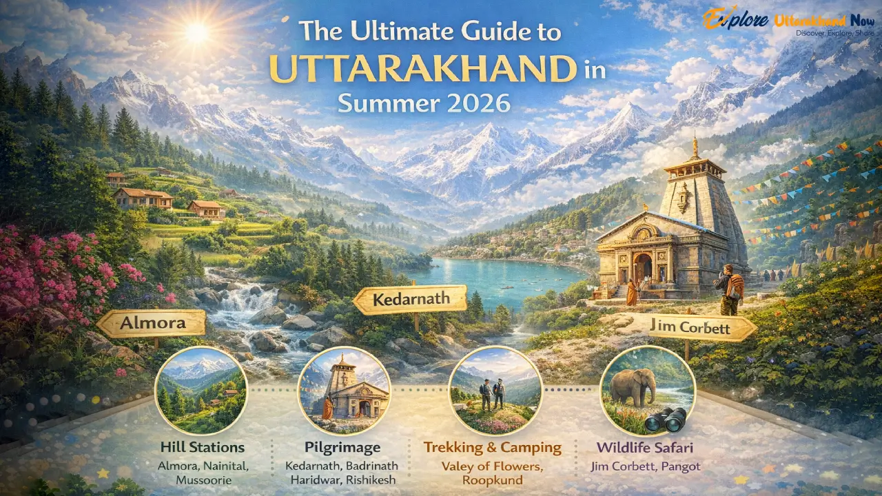
Oh, friends, let me take you back to that moment when I first stepped into the Chenap Valley. The air was crisp and alive with the whisper of the wind rustling through endless meadows dotted with wildflowers in every color imaginable—vibrant blues, sunny yellows, and delicate pinks swaying like they were dancing just for me. In the distance, a river gurgled softly over smooth stones, its melody blending with the occasional call of a mountain bird. And towering above it all, those majestic snow-clad peaks of the Himalayas stood like ancient guardians, their white caps glowing in the sunlight. It felt like I’d wandered into a secret world, untouched and pure, where time slows down and your worries just melt away. If you’ve ever dreamed of a trek that feels like discovering a hidden gem in the Himalayas, the Chenap Valley—sometimes called Chanap Valley by locals—is that place. Tucked away in the Chamoli district of Uttarakhand, this valley is a secret sanctuary bursting with alpine meadows, crystal-clear lakes, and breathtaking views of giants like Nanda Devi and Trishul. What makes the Chenap Valley Trek so special? It’s not overcrowded like some famous trails; it’s got that raw, intimate connection to nature that leaves you feeling renewed. And the best part? It’s accessible enough for aspiring trekkers but rewarding for seasoned adventurers. In this guide, I’m sharing everything I learned from my own journey there—the practical details, the thrills, the challenges, and the pure joy—so you can plan your own unforgettable trip with confidence. Whether you’re a nature lover craving serene landscapes or an adventure seeker ready for a moderate challenge, this trek will steal your heart. Unveiling the Chenap Valley Trek Picture this: you’re weaving through lush forests of oak and rhododendron, the scent of pine filling your lungs, and suddenly the trail opens up to sweeping vistas of bugyals—those high-altitude meadows that look like nature’s own carpet. The allure of the Chanap Valley Trek lies in its untouched beauty; it’s like the Valley of Flowers’ quieter sibling, with fewer crowds and just as much magic. Located in the Garhwal Himalayas, it’s a paradise for anyone who wants to immerse themselves in alpine flora, spot rare orchids and primulas blooming in summer, and gaze at snow peaks that seem close enough to touch. One of the things I love most is how doable it is from Delhi—it’s not some remote expedition that requires weeks of travel. The Chenap Valley from Delhi is about a 9-10 hour drive to the starting point, making it perfect for a weekend escape turned adventure. The total Chenap Valley Trek distance is around 20-25 km of actual walking, spread over a few days, so it’s not overwhelmingly long but packed with variety. You’ll hike through remote villages, cross gentle streams, and ascend to flower-filled ridges that offer panoramic rewards. Along the trail, some of the most captivating Chenap Valley places to visit include the serene Chenap Lake, surrounded by deodar forests where the water mirrors the sky like a painting; the expansive Chenap Bugyal meadows, alive with butterflies and wild grass up to your waist; and higher up, spots like Dhar Kharak for camping under the stars with views of Hathi Parbat. There’s even a chance to explore nearby Sona Sikhar if you’re feeling energetic—it’s an optional side jaunt with Brahma Kamal flowers dotting the path. This trek isn’t just about the distance; it’s about those moments of awe that make you feel alive. Trek Snapshot Let me give you a quick overview of what to expect on the Chenap Valley Trek—think of this as your handy cheat sheet, pulled straight from my notes. I remember poring over similar details before I went, and it made everything feel less daunting. To make it easy, here’s a simple breakdown: Trek Difficulty: Moderate. In practical terms, this means it’s great for fit beginners or those with some hiking experience under their belt. You’ll face steady ascents that get your heart pumping, but nothing extreme like sheer rock climbs. Expect 4-6 hours of walking per day on uneven terrain—think forest paths, meadow strolls, and a bit of steep uphill that builds character without breaking you. If you can handle a daily workout and enjoy being outdoors, you’ll thrive here. Just listen to your body and pace yourself. Trek Duration: About 8-9 days total from Delhi back to Delhi, including travel time. The actual trekking spans 4-5 days, with 4-6 hours of walking each day. This gives you buffer for rest, acclimatization, and soaking in the views—I wouldn’t rush it; the valley deserves your full attention. Trek Distance: The Chenap Valley Trek distance is approximately 20-25 km of pure trail time, but with side explorations, it feels even more immersive. Basecamp: The trek kicks off from Thaing Village, a quaint, secluded hamlet perched on a hillside opposite Joshimath. It’s got this peaceful, rustic vibe—think stone houses, friendly locals tending to their farms, and kids playing in the fields. Staying here feels like stepping into a simpler time, with the Alaknanda River rushing below. Highest Altitude: You’ll reach up to about 4,050 meters (around 13,300 feet) at Sona Sikhar or the upper meadows. The main Chenap Bugyal sits at 3,048 meters (about 10,000 feet), so altitude is a factor, but gradual gains help with acclimatization. I felt a bit winded at first, but the fresh air soon had me energized. Pickup Point: Usually from Joshimath or Dehradun’s bus stand/railway station. Most groups assemble in Rishikesh or Haridwar first, then head up. If you’re coming solo, aim for Dehradun as your entry point—it’s well-connected. Best Time: Hands down, May-June and September-October. These shoulder seasons mean wildflowers in full bloom during summer (May-June), with clear skies and minimal rain, or crisp autumn colors and golden light in September-October. Chenap Valley temperature ranges from a comfortable 15-25°C (59-77°F) during the day in these months, dropping to 5-10°C (41-50°F) at night—pack layers! Avoid monsoon (July-August) for slippery trails and winter (December-February) unless you’re
Top 10 Solo Treks in Uttarakhand: Your Ultimate Guide to Himalayan Solitude
When you think of Uttarakhand, the mind immediately drifts to towering peaks framed against an endless sky, forests of oak and rhododendron whispering in the wind, and meadows that seem to have been painted by some divine hand. For those who have ever dreamed of walking alone in these mountains, feeling the crunch of snow under their boots or the spray of mountain streams on their faces, Uttarakhand is nothing short of a spiritual homecoming. Solo trekking here is not just about moving from one campsite to another. It is about peeling back layers of fear and doubt, embracing freedom, and finding yourself in the silence of Himalayan solitude. Every climb tests your resilience, every river crossing offers courage, and every mountain top rewards you with a proud whisper that says, “You did this, and you did this alone.” If you’ve ever wondered where you can go solo travel in Uttarakhand, this guide is written for you. What follows are ten of the best treks in Uttarakhand, each with its own song, its own rhythm, waiting for you to walk alongside it. Kedarkantha Trek The Kedarkantha trek is often described as a rite of passage for solo trekkers. It is moderately demanding but very approachable, usually completed in about five to six days. What makes it so unforgettable is the 360-degree summit view. From the top, you see an endless line of snow peaks—Swargarohini, Bandarpoonch, and Black Peak standing tall like guardians of the Garhwal Himalayas. The campsites, especially Juda ka Talab, are magical with frozen ponds in winter and star-studded skies at night. Solo trekker’s note: Kedarkantha has a well-marked trail with a friendly flow of fellow trekkers, making it one of the safest options if you’re venturing into solo Himalayan trekking for the first time. Nag Tibba Trek If you’re short of time but craving adventure, the Nag Tibba trek is your answer. It is friendly for beginners, completed in just two days, and requires only moderate effort. At the summit, you’ll be gifted with clear views of Srikanth, Bandarpunch, Kedarnath, and Gangotri peaks. Walking through thick oak and deodar forests, you’ll hear the wind rustle through ancient trees while village dogs sometimes trot along as your only Solo trekker’s note: Because it is short and accessible, this trek attracts many weekend adventurers. It’s a wonderful place to bump into other solo explorers while still finding pockets of solitude when you need it. Har Ki Dun Trek Har Ki Dun, meaning “Valley of Gods,” is where time seems to pause. This trek is moderately difficult, taking about six to seven days. The trail is a sweeping curve of meadows, river crossings, and grand snow peaks like Swargarohini. Along the way, you will pass through ancient villages where wooden homes and simple lifestyles remind you of what simplicity looks like. You will also hear countless local stories tied to Mahabharata legends. Solo trekker’s note: The trail is longer and a bit quieter than others, so a GPS or local guide is helpful, especially if you’re solo. The reward, however, is a solitude that feels timeless. Dayara Bugyal Trek A meadow so vast it feels like the earth finally breathes free—that’s Dayara Bugyal. This trek is easy to moderate, generally enjoyed in four to five days. The meadows roll out beneath miles of sky, changing colors with the season: snowbound silence in winter, wildflower carpets in summer. The sight of Mount Bandarpoonch from these meadows is poetry for the eyes. Solo trekker’s note: The path is clear, and the terrain is forgiving, making this a confidence-boosting choice for solo trekkers. Camp under the wide meadow skies, and you’ll discover why silence is often the sweetest companion. Chopta Chandrashila Trek Chopta is often called the mini Switzerland of India, and rightly so. This trek, taking four to five days, is easy to moderate. It takes you through forests lined with rhododendrons, to Tungnath, the highest Shiva temple in the world, and finally to the Chandrashila summit. At sunrise, the Himalayan range glows like molten gold, a memory that etches itself deep into the heart. Solo trekker’s note: Because of its religious significance and popularity, there’s always some company on the trail. If you want the comfort of knowing you’re never too far from help, this is a comforting choice. Valley of Flowers Trek When monsoon rains brush their magic over the Himalayas, the Valley of Flowers comes alive in riotous bloom. This trek, about six days in duration, is moderately easy but seasonally dependent, best done from July to early September. Imagine walking through alpine meadows where every step reveals new hues—blue poppies, brahmakamal, orchids—all framed by misty peaks. Add the nearby Hemkund Sahib Gurudwara, sitting by a glacial lake, for the kind of peace that anchors your soul. Solo trekker’s note: This is one of the most secure treks for solos because of clear, well-trodden paths and the steady presence of pilgrims heading to Hemkund Sahib. Brahmatal Trek If you love trekking in winter, Brahmatal is a pure gift. Taking about five to six days, it is moderate in difficulty. Frozen lakes, oak and rhododendron forests, and a summit view of Mt Trishul and Nanda Ghunti make it truly spectacular. On a clear night, you’ll find the Milky Way stretching out above the snowfield like an ancient story still being told. Solo trekker’s note: Winter brings heavy snow, so if this is your solo adventure, ensure you have good gear and maybe share nights at local lodges along the way. Kuari Pass Trek Known as the Curzon Trail, Kuari Pass is a moderate trek of six to seven days. The allure here lies in its grand vistas of some of the tallest Himalayan peaks, including Kamet, Dronagiri, Chaukhamba, and Nanda Devi herself. The trail winds through high meadows where shepherds graze their flocks, and in the evenings, you feel cocooned in an untouched world. Solo trekker’s note: Trekkers often say Kuari’s trail feels like the perfect blend of challenge
Discover the Untouched Beauty of Chaainsheel Bugyal Trek in Uttarakhand
Imagine standing atop a high-altitude meadow, surrounded by a sea of vibrant wildflowers, with snow-capped Himalayan peaks piercing the sky in every direction. The air is crisp, the silence profound, and the only sounds are the gentle rustle of grass and the distant call of a Himalayan monal. This is Chaainsheel Bugyal, a hidden treasure in Uttarakhand’s Uttarkashi district, waiting to be explored by adventure enthusiasts, solo travelers, and couples seeking an authentic, offbeat Himalayan experience. If you’re yearning for a trek that blends breathtaking landscapes, rich biodiversity, and a touch of spiritual serenity, the Chaainsheel Bugyal Trek is calling your name. What is the Height of Chaainsheel? Nestled at an altitude of approximately 11,700 to 11,750 feet (around 3,600 meters), Chaainsheel Bugyal is a high-altitude alpine meadow, or “bugyal,” in the Garhwal Himalayas. This elevation offers a sweet spot for trekkers: high enough to immerse you in the raw beauty of the Himalayas, yet accessible enough for beginners with decent fitness levels. The altitude provides stunning panoramic views of iconic peaks like Bandarpoonch, Black Peak, and Swargarohini, making every step a visual feast. Why is Chaainsheel Bugyal Trek Special? Unlike more popular treks like Dayara Bugyal (famous for its vast meadows and winter snowscapes), Chaainsheel remains a relatively untouched paradise. Its remote location on the border of Uttarakhand and Himachal Pradesh, within the Govind Wildlife Sanctuary, ensures fewer crowds and a pristine environment. In 2017, Uttarakhand Tourism crowned it the “Trek of the Year,” a recognition that sparked interest among trekkers but preserved its offbeat charm. This trek isn’t just about reaching a destination; it’s about immersing yourself in nature’s grandeur and the rich cultural tapestry of the Garhwali people. The Chaainsheel Valley is a mosaic of sprawling meadows, dense forests, and gurgling streams. It’s a place where locals believe the Pandavas from the Mahabharata once roamed, leaving behind sacred relics like the foot impressions of Bhima. The region is also mentioned in the Skanda Purana as a “tapsya sthal” (land of penance), where sages meditated, infusing the area with a spiritual aura. For those seeking more than just adventure, Chaainsheel offers a chance to connect with nature and history on a deeper level. Chaainsheel Bugyal Trek Distance and Route The Chaainsheel Bugyal Trek typically spans 32 to 45 kilometers on foot, covered over 6 to 8 days, depending on the itinerary. The journey begins from base camps like Himari, Balawat, or Kushkalyani, small villages in Uttarkashi that serve as gateways to this Himalayan wonderland. The trek involves a mix of gradual ascents, ridge walks, and meadow crossings, with daily treks ranging from 4 to 12 kilometers. A typical itinerary might look like this: Day 1: Drive from Dehradun to Himari/Balawat (210 km, 8-9 hours). Day 2: Trek from Himari to Akhoti Thach (12 km, 5-6 hours, 8,350 feet). Day 3: Trek to Gujar Hat (4 km, 3-4 hours, 9,750 feet). Day 4: Reach Chaainsheel Bugyal (6 km, 4-5 hours, 11,750 feet) and explore the meadows. Day 5-7: Explore nearby bugyals like Sunoiti or Tikula Thach, or descend back via Akhoti Thach to Himari. Day 8: Drive back to Dehradun. The trail is moderate, with some steep sections, making it suitable for beginners with good endurance and experienced trekkers alike. The total distance by road (from Dehradun and back) is around 420 kilometers. Characteristics of Chaainsheel Uttarakhand Trek The Chaainsheel Uttarakhand Trek is a sensory delight. You’ll traverse dense forests of oak, pine, rhododendron, and deodar, which give way to expansive meadows dotted with snow patches. The trail offers breathtaking views of peaks like Bandarpoonch (6,300 meters), Kalanag, and Swargarohini, with the Ganga and Yamuna rivers’ watersheds visible in the distance. The ridge walks are a highlight, offering 360-degree vistas that make you feel like you’re walking on the roof of the world. The trek’s remote setting ensures a peaceful escape from crowded tourist trails. You’ll pass through quaint Garhwali villages like Hadwari and Himari, where you can interact with locals and glimpse their rustic lifestyle. Camping under a starlit sky, far from city lights, adds a magical touch to the experience. Flora and Fauna: A Biodiversity Hotspot Chaainsheel Bugyal is a haven for nature lovers. In spring (May-June), the meadows burst into a riot of colors with wildflowers like Brahma Kamal, Blue Poppy, and Cobra Lily. The forests are alive with rhododendrons in vibrant reds and pinks, while oak and pine trees provide shade and serenity. The Govind Wildlife Sanctuary is home to diverse wildlife, including the elusive snow leopard, Himalayan monal, musk deer, red fox, and koklass pheasant. Butterflies flutter around the flowers, and the air hums with the songs of birds, making it a paradise for birdwatchers and photographers. Chaainsheel Uttarakhand Weather and Temperature The weather in Chaainsheel Uttarakhand is typical of high-altitude Himalayan regions. Daytime temperatures range from 10°C to 15°C, while nights can dip below freezing, especially at higher campsites. Early summer (May-June) brings patches of snow and blooming meadows, while autumn (September-October) offers clear skies and crisp air. Monsoon months (July-August) are best avoided due to heavy rainfall and slippery trails, which can make the trek challenging. Always check weather updates, as sudden changes are common at high altitudes. Why Choose Chaainsheel Bugyal Trek? Why should you lace up your boots for Chaainsheel? Here’s why: Untouched Beauty: Unlike mainstream treks, Chaainsheel remains less crowded, offering a serene, authentic Himalayan experience. Moderate Challenge: With an altitude of 11,750 feet and a moderate difficulty level, it’s perfect for beginners and seasoned trekkers alike. Cultural Immersion: Interact with Garhwali villagers, learn about local myths, and experience their warm hospitality. Biodiversity: From rare wildflowers to elusive wildlife, Chaainsheel is a nature lover’s dream. Spiritual Connection: The region’s mythological significance and tranquil aura make it ideal for introspection and meditation. Practical Wisdom for Your Chaainsheel Adventure Best Time to Visit The ideal windows for the Chaainsheel Bugyal Trek are May to June and September to October. In spring, the meadows are a vibrant carpet of wildflowers, and
Top 10 Weekend Summer Treks in Uttarakhand: A Himalayan Adventure Awaits
Close your eyes and imagine this: a warm summer breeze carries the scent of pine and wildflowers, your boots crunch on a forest trail, and the mighty Himalayas loom ahead, their peaks kissed by golden sunlight. Uttarakhand in summer is a trekker’s dream—lush meadows, vibrant forests, and cool mountain air make it the perfect season for a weekend escape. These trails aren’t just paths; they’re stories woven with adventure, serenity, and nature’s raw beauty. Let me take you on a journey through the top 10 weekend summer treks in Uttarakhand, where every step feels like a conversation with the mountains. 1. Chopta Chandrashila Trek: Chasing Himalayan Sunrises Nothing beats the thrill of watching the first rays of sun paint Nanda Devi and Trishul in hues of gold from Chandrashila’s summit. The Chopta Chandrashila Trek is a summer stunner, with rhododendrons blooming in fiery reds and pinks along the trail. The air is crisp, the skies clear, and the views? Absolutely soul-stirring. Altitude: 12,083 ft Trek Distance: 8-10 km (round trip) Difficulty Level: Easy to Moderate Duration: 2-3 days Route from Dehradun: Drive 200 km to Chopta via Rishikesh, Devprayag, and Rudraprayag (7-8 hours). Trek from Chopta to Tungnath and Chandrashila. Best Time for Summer: April to June Permits: No permits required; register at Chopta’s forest checkpost. Tip: Pack light layers—mornings are chilly. Stay hydrated for the summit push. The trail winds through dense forests, with the occasional rustle of leaves hinting at a musk deer nearby. At Tungnath, the highest Shiva temple in the world, the air feels sacred. Camp under a starlit sky, and let the mountains whisper their secrets. 2. Deoria Tal Trek: A Lakeside Escape For a quick summer getaway, the Deoria Tal Trek is pure magic. This easy trail leads to a serene lake reflecting Chaukhamba’s majestic peaks. In summer, the surrounding meadows burst with wildflowers, and the lake shimmers under clear blue skies. Altitude: 7,998 ft Trek Distance: 6 km (round trip) Difficulty Level: Easy Duration: 1-2 days Route from Dehradun: Drive 170 km to Sari village via Rishikesh and Rudraprayag (6-7 hours). Trek 2.5 km from Sari to Deoria Tal. Best Time for Summer: April to June Permits: No permits needed; pay a small camping fee at Sari. Tip: Pitch a tent by the lake for a night of stargazing. Carry a light jacket for cool evenings. The trail is gentle, weaving through oak and pine forests where sunlight dances on the forest floor. At Deoria Tal, sip chai from a thermos and let the tranquility sink in. It’s perfect for beginners or families craving an easy Himalayan trek. 3. Nag Tibba Trek: The Serpent’s Summit Known as the “Serpent’s Peak,” the Nag Tibba Trek is a weekend favorite for its mix of adventure and accessibility. Summer brings lush greenery and clear views of Bandarpunch and Swargarohini, making every step a visual treat. Altitude: 9,914 ft Trek Distance: 16 km (round trip) Difficulty Level: Easy to Moderate Duration: 2 days Route from Dehradun: Drive 85 km to Pantwari via Mussoorie (3-4 hours). Trek 8 km from Pantwari to Nag Tibba summit. Best Time for Summer: April to June Permits: No permits required. Tip: Hire a local guide from Pantwari for navigation and local folklore. Pack sunscreen for exposed sections. The trail meanders through forests and meadows, with streams gurgling alongside. At the summit, the 360-degree panorama feels like a reward for your soul. Bonfires and stories under the stars make this trek unforgettable. 4. Kedarkantha Trek: Meadows and Mountain Magic The Kedarkantha Trek in summer swaps its snowy charm for lush meadows and vibrant forests. The trail to the summit offers sweeping views of Swargarohini and Black Peak, with pine-scented air keeping you company. Altitude: 12,500 ft Trek Distance: 20 km (round trip) Difficulty Level: Moderate Duration: 4-5 days Route from Dehradun: Drive 190 km to Sankri via Mussoorie and Purola (7-8 hours). Trek from Sankri to Kedarkantha via Juda ka Talab. Best Time for Summer: April to June Permits: Forest permits required (arranged by trek operators). Tip: Rent trekking poles in Sankri for steep sections. Book with a local operator for logistics. Juda ka Talab, a serene lake fringed by pines, is a highlight—perfect for a reflective pause. The trail feels alive with birdsong and the rustle of leaves, making it a summer must-do for Himalayan trekkers. 5. Dayara Bugyal Trek: Meadows in Full Bloom The Dayara Bugyal Trek is a summer spectacle, with its sprawling alpine meadows bursting with wildflowers. The views of Bandarpunch and Draupadi ka Danda are breathtaking, and the trail feels like a walk through a Himalayan painting. Altitude: 12,057 ft Trek Distance: 20 km (round trip) Difficulty Level: Easy to Moderate Duration: 4-5 days Route from Dehradun: Drive 190 km to Barsu via Uttarkashi (7-8 hours). Trek from Barsu to Dayara Bugyal. Best Time for Summer: May to June Permits: Forest permits needed (arranged by guides). Tip: Wear sturdy shoes for rocky patches. Carry a hat for sun protection. The meadows stretch endlessly, dotted with grazing sheep and framed by snow-capped peaks. At camp, lie back and watch clouds drift by—it’s a summer trek that makes you feel one with nature. 6. Dodital Trek: A Tranquil Retreat The Dodital Trek leads to a pristine lake cradled by dense forests, where summer brings lush greenery and sparkling waters. Legend links this lake to Lord Ganesha’s birth, adding a spiritual layer to the adventure. Altitude: 9,900 ft Trek Distance: 22 km (round trip) Difficulty Level: Easy to Moderate Duration: 4-5 days Route from Dehradun: Drive 190 km to Sangamchatti via Uttarkashi (7 hours). Trek from Sangamchatti to Dodital. Best Time for Summer: April to June Permits: Forest permits required (available at Uttarkashi). Tip: Pack rain gear—summer showers are common. Try fishing at Dodital (with permission). The trail follows the Asi Ganga river, its gentle roar a soothing backdrop. At Dodital, the silence is profound, broken only by the occasional splash of trout. It’s a trek for those seeking peace.
All You Need to Know About the Dehradun-Mussoorie Ropeway
Hey there, travel enthusiasts and Uttarakhand lovers! If you’ve ever driven the winding, traffic-packed road from Dehradun to Mussoorie, you know it’s a journey filled with breathtaking views but also plenty of patience-testing moments. Well, hold onto your hats because the Dehradun-Mussoorie Ropeway is set to change the game! This ambitious project promises to whisk you from the bustling capital to the serene “Queen of Hills” in mere minutes, all while offering jaw-dropping aerial views. Let’s dive into everything you need to know about this exciting development, from its purpose to its progress, and why it’s got everyone buzzing. Dehradun to Mussoorie Ropeway: The Big Picture Imagine cutting a 1.5-to-3-hour road trip down to just 15-20 minutes. That’s the heart of the Dehradun-Mussoorie Ropeway project. It’s designed to slash travel time, ease the notorious traffic congestion on the Dehradun-Mussoorie road, and give tourism a massive boost. Mussoorie, with its colonial charm and Himalayan vistas, attracts over 10,000 visitors daily during peak seasons, clogging roads and parking spaces. This ropeway is Uttarakhand’s answer to smarter, greener, and faster travel. The project is a public-private partnership (PPP) led by Mussoorie Sky Car Company Pvt. Ltd., a consortium including FIL Industries, SRM Engineering LLP, and French technology giant POMA SAS. With a budget of ₹300 crore, it’s not just a local endeavor—it’s set to be India’s longest passenger ropeway, spanning 5.5 kilometers. The Uttarakhand government is all in, seeing it as a way to elevate tourism revenue and create jobs, especially in areas like Purkul village. The Plan: How Will the Ropeway Work? Picture this: you hop onto a sleek, 10-seater diamond cabin in Dehradun and glide over lush valleys to Mussoorie in no time. The ropeway will stretch 5.5 km, connecting Purkul village in Dehradun to Library Chowk in Mussoorie. Unlike the 33-km road route, this mono-cable detachable gondola system will cover the distance directly, offering a capacity of 1,300 passengers per hour per direction. That’s enough to handle both tourists and locals with ease. The cabins are modern, fully ventilated, and equipped with automatic doors and panoramic windows for those Instagram-worthy shots of the Doon Valley and Himalayan peaks. There are two main terminals—Purkul village (lower terminal) and Library Chowk (upper terminal)—with no intermediate stations planned. A 10-story parking facility in Purkul, accommodating over 2,000 vehicles, will also feature cafes and restrooms, making the experience seamless. Where Are We Now? Current Status As of May 2025, the ropeway is under construction, with work progressing at a steady clip. The lower terminal in Purkul village is taking shape, with facilities like parking, ticket counters, and waiting areas being developed. In Mussoorie, the upper terminal at Library Chowk is also moving forward, with approach roads and foundational work underway. Land acquisition and environmental clearances, which posed earlier hurdles, have largely been resolved, keeping the project on track. When Will It Be Ready? The first phase of the ropeway is slated for completion by September 2026, a timeline echoed by multiple sources. While some reports mention the possibility of full operations by the end of 2026, the focus remains on ensuring world-class quality and safety. Delays could arise from unpredictable Himalayan weather or unforeseen technical challenges, but the consortium and government are pushing for timely delivery. So, mark your calendars—this could be your next big adventure in Uttarakhand Dehradun to Mussoorie: Distance and Time Saved Currently, the road from Dehradun to Mussoorie is about 33 km, taking anywhere from 1.5 to 3 hours depending on traffic, weather, or those pesky weekend jams. The ropeway, covering just 5.5 km as the crow flies, will shrink that to 15-20 minutes. That’s a game-changer for tourists craving more time to explore Mussoorie’s Mall Road or locals commuting for work. Plus, no more dodging landslides or snow-blocked roads Where Does It Start and End? The ropeway kicks off at Purkul village, near Dehradun, a convenient spot accessible from the city’s main hubs like ISBT or the railway station. It lands at Library Chowk in Mussoorie, right in the heart of the hill station, close to major attractions. The lower terminal will be a mini-hub with parking and amenities, while the upper terminal will blend into Mussoorie’s vibrant core, making it easy to jump into the town’s charm. Is the Ropeway Running Yet? Not yet! The ropeway is still in the construction phase, with no public operations as of now. Trial runs or testing phases may begin closer to the 2026 completion date, but for now, you’ll need to stick to the road. Keep an eye out for official announcements from the Uttarakhand government or Mussoorie Sky Car Company for updates on when you can book that first ride. How Much Will Tickets Cost? Exact ticket prices haven’t been announced, but officials hint at affordable fares to attract both tourists and locals. Estimates suggest a one-way trip could be competitively priced compared to taxis or buses, with round-trip options likely available. There’s talk of potential discounts for locals, students, or seniors, but we’ll need to wait for official confirmation. For context, similar ropeways in India, like the Gulmarg Gondola, charge around ₹700-₹1,600 per person, so expect something in that ballpark. Is It Expensive? Will the ropeway be worth it? Let’s break it down. A taxi from Dehradun to Mussoorie can cost ₹1,500-₹2,000 one-way, while shared cabs or buses range from ₹100-₹300. If the ropeway’s fare lands around ₹500-₹1,000 per person, it’s pricier than a bus but cheaper than a private cab—plus, you get a scenic, hassle-free ride. For tourists, the aerial views and time saved make it a no-brainer. For daily commuters, the cost might feel steep unless discounts are offered, but the convenience could still win them over. Why This Ropeway Rocks This project is more than just a quicker commute. Here’s why it’s a big deal: Faster Travel: 15-20 minutes versus hours on the road. Stunning Views: Gliding over valleys and forests is a tourist magnet. Eco-Friendly: Running on electricity, it cuts down on vehicle emissions,
Monsoon Treks in Uttarakhand: Best Trails, Safety Tips & Magical Green Landscapes
Hey, fellow trailblazer! If you’ve ever thought of trekking just for sunny days, let me change your mind with Uttarakhand in the monsoon. Picture this: misty hills, gushing waterfalls, and trails so green they look painted—yep, that’s what July to September brings here. I’ve trekked these paths in the rain, and trust me, it’s a whole different kind of magic. Ready to dive into the wet, wild beauty of Uttarakhand’s monsoon treks? Let’s lace up and go! Introduction to Monsoon Treks in Uttarakhand Monsoon turns Uttarakhand into a lush paradise—think emerald meadows, fog curling around peaks, and streams that roar to life. It’s not just the scenery; the vibe’s unique too—fewer crowds mean you’ve got these trails almost to yourself. Sure, it’s wet and muddy, but that’s part of the charm. Waterfalls crash louder, flowers pop brighter, and the air? So fresh you’ll feel reborn. If you’re up for a little adventure with a lot of green, this is your season. Understanding Monsoon Season in Uttarakhand Monsoon here runs from July to September, with August being the wettest—think heavy downpours that can soak you in minutes. Weather’s a mixed bag: misty mornings, sudden showers, and the occasional clear spell. Kumaon (like Almora) gets a bit less rain than Garhwal (say, Rudraprayag), where landslides can be a real buzzkill. Stick to safer zones—avoid places like Rudraprayag or Chamoli if you hear landslide chatter. Check the forecast, and we’ll be golden. Best Monsoon Treks in Uttarakhand Here’s my hit list of monsoon treks—each one’s a stunner: Valley of Flowers Trek Why it’s epic: Monsoon wakes up over 300 flower species—carpets of color against misty peaks. It’s like nature’s fireworks. You’ll need a permit (easy to grab at Govindghat), and I’d pair it with Hemkund Sahib for that high-altitude lake bonus. Rain makes it slippery, but the bloom? Worth every squishy step. Nag Tibba Trek Perfect for newbies—2 days, 1 night, starting from Pantwari near Dehradun. The meadows turn into cloud-covered dreamscapes, and the views stretch to Bandarpunch peak. It’s short, sweet, and monsoon-friendly—my go-to for a quick escape. Har Ki Dun Trek Less crowded in the rains, this one’s a gem. You’ll trek through ancient villages like Osla—think wooden houses and local chai stops. The catch? Rivers swell, so crossings can get dicey—stick with a guide. The green valleys and quiet trails make it unforgettable. Dayara Bugyal Monsoon Trek Rolling meadows go full emerald in the rains—lower altitude means fewer risks. It’s a photographer’s playground with dramatic clouds and soft light. Easy enough for a chill trek, but the beauty’s next-level. Monsoon-Specific Trekking Gear Checklist Rain changes the game, so here’s what I pack: Must-Haves: Waterproof backpack cover (trust me, soggy gear sucks), quick-dry clothes (cotton’s a no-go—it clings like a wet dog), and non-slip trekking shoes—grip is life on muddy trails. Pro Tips: Double-bag your phone and camera in zip-locks—water’s sneaky. A trekking pole’s your best friend for balance on slick rocks. Oh, and a lightweight poncho beats an umbrella—hands-free wins! Safety Considerations for Monsoon Treks Safety’s non-negotiable in the rain. Landslides are real—check the Uttarakhand Disaster Portal (disaster.uk.gov.in) before you head out. River crossings? Never after 3 PM—water levels spike fast. Keep SDRF (State Disaster Response Force) numbers handy (like 112) and know the nearest forest office—just in case. I’ve dodged a few sketchy moments by playing it smart, and you should too. Alternate Activities for Heavy Rain Days Pouring too hard to trek? No sweat—try these: Mountain Villages: Kausani got tea estates and misty views; Chaukori’s sunrise points are fog-kissed perfection. Indoor Fun: Take a Kumaoni cooking class—learn to whip up Aloo ke Gutke—or explore temple trails like Jageshwar Dham. Rainy days can still be awesome if you pivot. Best Time Windows Within Monsoon Timing’s everything: Early Monsoon (July): Fresh greenery, lighter showers—great for a crisp start. Late Monsoon (Sept): Skies clear up, rhododendrons bloom, and trails dry out a bit. August is peak rain—beautiful but intense—so pick your window based on how wet you’re willing to get! How to Reach Starting Points for Monsoon Treks Getting to the trailheads is easy: Valley of Flowers: Train to Haridwar, then a shared jeep to Govindghat (10–12 hours total). Roads can get bumpy, so brace yourself! Nag Tibba: Drive from Dehradun to Pantwari (3 hours)—taxis are cheap and quick. Book ahead for jeeps, especially in July—monsoon trekkers are a small but eager bunch. FAQs About Monsoon Trekking in Uttarakhand Leeches a problem? Yep—carry salt or wear leech socks (game-changer). Beginner-friendly? Stick to Nag Tibba—others need some grit. Clouds block views? Sometimes, but mornings often clear—set that alarm! Conclusion: Embrace the Rainy Adventure Monsoon in Uttarakhand is raw, wild, and gorgeous—trails glow green, waterfalls roar, and the quiet feels alive. It’s not always easy—mud, leeches, the odd downpour—but that’s what makes it real. Before you book, double-check your gear (waterproof everything!), pick a safe trail, and dive in. Want more adventure ideas? Peek at winter camping tips or summer destinations—but for now, let’s embrace the rain. You in?
Skiing in Uttarakhand: Auli’s Snow Paradise & Best Winter Adventures
Hey, friend! Ever dreamed of gliding down snowy slopes with the Himalayas as your backdrop? Well, Uttarakhand’s got you covered, and trust me, it’s a winter wonderland you won’t forget. Among all the snowy spots, Auli stands out as India’s skiing superstar. Ready to explore why it’s the ultimate destination for shredding powder? Let’s dive in! Introduction to Skiing in Uttarakhand Picture this: crisp mountain air, powdery snow under your feet, and peaks like Nanda Devi watching over you. That’s skiing in Uttarakhand for you—India’s top spot for winter thrills. While the state’s got a bunch of snowy gems, Auli steals the show with its world-class slopes and jaw-dropping views. It’s not just a place to ski; it’s where you feel the rush of the Himalayas. So, grab your gear, and let’s see what makes this region a snow-lover’s paradise. Where Can You Ski in Uttarakhand? Wondering where to ski in Uttarakhand? Here’s the lowdown: Auli: The king of the hill with Asia’s longest slopes—3 to 10 km of pure skiing bliss. Munsiyari: An offbeat pick in the Kumaon region, with quieter trails and epic views. Dayara Bugyal: Perfect for beginners, these high-altitude meadows turn into a snowy playground in winter. Auli’s the headliner, but if you’re up for variety, these spots won’t disappoint. Why is Auli So Famous for Skiing? So, why is Auli the talk of the town? First off, it’s got the Joshimath-Auli Ropeway—India’s highest and longest at 4 km—lifting you straight to ski heaven. Then there’s the slopes: international-grade and steep enough to host national skiing championships. Oh, and the views? You’re flanked by giants like Nanda Devi, Kamet, and Dronagiri. It’s no wonder Auli’s dubbed the skiing paradise of Garhwal—check out why here. Famous? You bet it is! Best Time for Skiing in Auli Timing’s everything, right? The best months for skiing in Auli are December to February, when the snow’s deep and fluffy—prime powder conditions. January’s my personal fave; the snow’s super consistent. Skip March unless you like slush, and definitely avoid monsoons—everything’s closed. Want that perfect run? Plan for mid-winter, and you’re golden. Ski Resorts in Uttarakhand Where do you crash after a day on the slopes? Auli’s got options: Luxury Stays: Cliff Top Club offers ski-in/ski-out access—fancy, right? Budget Picks: GMVN Auli is government-run, affordable, and cozy enough for a good night’s sleep. Both put you close to the action, so you’re not trekking miles to ski. Ice Skiing in Uttarakhand: What’s Unique? Auli’s snow is something special—dry, fluffy powder that’s a skier’s dream. It’s perfect for ice skiing, giving you smooth, fast runs. Imagine this: you’re carving down a slope, snow spraying around you—total movie moment. For a taste, picture a 1-minute reel titled “Auli Skiing Thrills”—slopes, spins, and Himalayan vibes. Safety’s key, though—always go with a certified instructor. No hero moves here! Jet Skiing in Uttarakhand? Reality Check Jet skiing in Uttarakhand? Sorry, no dice. The lakes and rivers freeze up in winter, so water sports are off the table. But don’t pout—try rafting in Rishikesh when it’s warmer, or go paragliding in Nainital. For now, let’s stick to the snow! Skiing Courses, Costs & Equipment New to skiing? Auli’s got beginner courses—think 7 days for ₹8,000–₹15,000, depending on the package. Gear’s easy to rent: skis, boots, and poles run ₹500–₹1,000 per day. Bring your own gloves and goggles if you’ve got ‘em, but otherwise, you’re set. It’s affordable fun with pro guidance—perfect for your first turns. How to Reach Auli for Skiing? Getting to Auli’s a bit of an adventure: By Air: Fly to Jolly Grant Airport in Dehradun, then drive 10 hours. By Train: Haridwar’s your stop—8 hours by road from there. By Road: From Delhi, it’s Rishikesh → Joshimath → Auli—about 12 hours. Joshimath’s your base; grab a local taxi or the ropeway up to Auli. Road trips through the hills are half the fun—just pack some snacks! Skiing Tips for Beginners First time on skis? Here’s what I’d tell you over coffee: Dress Smart: Layer up—thermals, waterproof jacket, gloves. It’s cold up there! Acclimatize: Chill in Joshimath for a day to adjust to the altitude. Stay Hydrated: Altitude can zap you—sip water or electrolytes to keep going. Take it slow, listen to your instructor, and you’ll be cruising in no time. FAQs About Skiing in Uttarakhand Got questions? I’ve got answers: Is Auli safe for first-timers? Totally—trainers keep it chill and controlled. Can kids ski? Yep, ages 8+ with kid-sized gear. Solo skiing? Only in guided zones—safety first! Beyond Skiing: Winter Activities in Uttarakhand Skiing’s not the only game in town. Try snowboarding in Auli if you’re feeling bold. The cable car joyrides give you unreal aerial views—perfect for Instagram. Or set up a snow camp near Gorson Bugyal—think starry nights and hot chai. Uttarakhand’s a winter playground; explore more in this winter holiday guide. Conclusion: Ready to Hit the Slopes? So, there you go—Auli’s your ticket to India’s best skiing, with killer slopes, epic views, and that Himalayan magic. December to February’s your window, and with these tips, you’re ready to carve it up. Bonus: nearby Nanda Devi National Park is worth a peek if you’ve got time. What’s stopping you? Book that ski package, grab your gear, and let’s make some snow memories in the Himalayas!
Panch Badri Yatra: A Complete Pilgrimage Guide to Uttarakhand’s Sacred Shrines
Hey there, friend! If you’re looking for a spiritual adventure that’s off the beaten path yet deeply rooted in Hindu mythology, the Panch Badri Yatra in Uttarakhand is calling your name. Picture this: five sacred shrines dedicated to Lord Vishnu, nestled amidst the breathtaking Himalayas, each with its own story and charm. Ready to explore this divine journey with me? Let’s get started. Introduction to Panch Badri So, what’s Panch Badri all about? It’s a pilgrimage to five holy temples—Badrinath, Yogadhyan Badri, Bhavishya Badri, Vridha Badri, and Adi Badri—scattered across Uttarakhand. These aren’t just random stops; they’re a spiritual constellation tied to Lord Vishnu, the preserver of the universe. For devotees, visiting all five is like piecing together a sacred puzzle, and for travelers like us, it’s a chance to soak in Uttarakhand’s natural beauty and rich heritage. Trust me, this isn’t just a trip—it’s a soul-stirring experience. The Sacred Concept of Panch Badri The legend goes that the great sage Adi Shankaracharya, a rockstar of Hindu philosophy, linked these shrines to the larger Char Dham Yatra. He’s said to have rediscovered Badrinath and established its prominence, but the other four Badri shrines have their own ancient tales. Together, they represent Vishnu’s divine presence across time—past, present, and future. For pilgrims, completing the Panch Badri Yatra is a way to connect with this timeless energy. Pretty cool, right? Which Are the Panch Badri? Let’s break it down—here are the five stars of this pilgrimage: Badrinath (Vishal Badri): The big one! This is the most famous, often just called Badrinath Temple. Yogadhyan Badri: The winter home of Lord Badrinath’s idol when the main temple shuts down. Bhavishya Badri: Known as the “Future Badri”—a mystical spot with a prophecy attached. Vridha Badri: The “Old Badri,” where Vishnu was worshipped long before Badrinath became a thing. Adi Badri: A cluster of 16 ancient temples with Gupta-era vibes. Each one’s unique, and I’ll guide you through them in detail soon! Detailed Guide to Each Panch Badri Temple Alright, let’s take a closer look at these sacred spots. Badrinath (Vishal Badri) Location: Chamoli district, perched on the Alaknanda River. Unique Feature: The Tapt Kund hot springs—perfect for a warm dip before darshan—and those jaw-dropping Himalayan views. Best Time: May to November (it’s closed in winter due to snow). Want more on this gem? Check out Exploring Badrinath Temple. Yogadhyan Badri (Joshimath) Location: Joshimath town, about 45 km from Badrinath. Unique Feature: This is where Lord Badrinath “chills” during winter—his idol is moved here with a grand procession. Best Time: Open year-round, so it’s your go-to when Badrinath’s snowed in. Bhavishya Badri (Subhain Village) Location: Near Joshimath in the Naitwar Valley. Unique Feature: Legend says this will be Badrinath’s future home when the current site becomes inaccessible. Best Time: May to October (you’ll need to trek a bit—pack good shoes!). Vridha Badri (Animath) Location: Animath village, just 7 km from Joshimath. Unique Feature: This ancient temple is where Vishnu was worshipped before Adi Shankaracharya shifted things to Badrinath. Best Time: April to November. Adi Badri (Karnaprayag) Location: Near Karnaprayag, 17 km from Ranikhet. Unique Feature: A stunning group of 16 stone temples from the Gupta dynasty—history buffs, you’ll love this! Best Time: Year-round, thanks to its lower altitude. What Are the 5 Badri Routes? Planning to hit all five? Here’s how to navigate: Badrinath Route: Rishikesh → Joshimath → Badrinath. Yogadhyan Badri Route: Straight to Joshimath town—easy peasy. Bhavishya Badri Route: Joshimath → Subhain (includes a short trek). Vridha Badri Route: Joshimath → Animath (a quick drive). Adi Badri Route: Ranikhet → Karnaprayag → Adi Badri. How to Reach Panch Badri? Getting there is half the fun! By Air: Fly into Jolly Grant Airport in Dehradun, then hit the road. By Train: Rishikesh or Haridwar are your closest stations—both well-connected. By Road: From Delhi, it’s a 12–14-hour drive to Joshimath via Rishikesh. Local taxis can take you temple-hopping from there. Pro tip: Roads can get winding, so keep some snacks handy! Planning the Panch Badri Yatra Here’s a 5-day itinerary to make it smooth: Day 1: Land in Rishikesh or Joshimath (your base camp). Day 2: Head to Adi Badri—explore those ancient temples. Day 3: Visit Vridha Badri and Yogadhyan Badri—both near Joshimath. Day 4: Trek to Bhavishya Badri—pack a picnic! Day 5: Wrap up with Badrinath Darshan—don’t miss the hot springs. Travel Tips: Pack woolens—higher altitudes get chilly, even in summer. Book stays in advance—options are limited in remote spots like Subhain. Love trekking? Pair this with the Valley of Flowers trek! Best Time to Visit Panch Badri Mark your calendar for May–June or September–October—perfect weather, clear skies. Skip July–August; monsoon landslides can throw a wrench in your plans. Spiritual and Cultural Significance The Panch Badri shrines are steeped in mythology. Vishnu meditated here, and the Pandavas from the Mahabharata are said to have passed through. Local priests still follow age-old rituals, and festivals like Badri Kedar Utsav bring the culture alive. Want more on Uttarakhand’s traditions? Dive into Unveiling Uttarakhand. FAQs About Panch Badri Yatra How long does it take? About 5–7 days, depending on your pace. Is it tough? Not really—most are accessible by road, except Bhavishya Badri’s trek. What’s nearby? Check out Nanda Devi National Park for a nature fix! Conclusion There you have it—the Panch Badri Yatra, a spiritual journey through Uttarakhand’s hidden gems. From Badrinath’s grandeur to Adi Badri’s ancient charm, it’s a pilgrimage that blends faith, history, and Himalayan magic. So, what do you say? Ready to embark on this divine adventure and feel the blessings of Lord Vishnu? Let me know how it goes—I’d love to hear your stories!
Panch Prayag of Uttarakhand: Sacred Confluences, Route & Spiritual Significance
Hey there! Ever thought about chasing rivers through the Himalayas, where every bend feels holy? That’s the Panch Prayag for you—five sacred river confluences in Uttarakhand that hum with spirituality. I’ve stood at a couple, toes in the icy water, feeling the weight of myths and mountains. These aren’t just pretty spots; they’re where faith flows as deep as the rivers themselves—washing away sins, blessing pilgrims, and dazzling you with Himalayan beauty. Curious about Uttarakhand’s spiritual side? Let’s explore the Panch Prayag together—I’ve got stories, routes, and tips to share! What is Panch Prayag? So, what’s Panch Prayag? Break it down: Panch means five, Prayag means confluence—five holy river mergers, simple as that. In Hindu culture, these spots are sacred—dip in the waters, and legend says your soul gets a clean slate. Tucked in the Garhwal Himalayas, they’re a pilgrimage of peace and power. Ready to meet them? The 5 Prayag Names & Their Sequence Here’s the Panch Prayag in sequence, flowing from highest to lowest: Vishnuprayag: Alaknanda meets Dhauliganga near Joshimath. Nandaprayag: Alaknanda joins Mandakini in Chamoli district. Karnaprayag: Alaknanda and Pindar merge on NH58. Rudraprayag: Alaknanda greets Mandakini, gateway to Kedarnath. Devprayag: Alaknanda and Bhagirathi unite—bam, the Ganga’s born! Each one’s a chapter in a riverine tale—let’s see why they’re famous. Why is Panch Prayag Famous? Why is Panch Prayag famous? Three big reasons: Mythological Significance: Think Vishnu meditating, King Nanda praying, or Karna seeking redemption—Mahabharata vibes run deep. Spiritual Power: Devprayag where the Ganga officially starts—huge for Hindus. Every confluence is a purification point. Scenic Beauty: Turquoise waters crash through green valleys with snow peaks watching—I’ve been mesmerized every time. It’s faith and nature in perfect harmony. The Route of Panch Prayag What is the route of Panch Prayag? The classic circuit starts at Rishikesh—your spiritual launchpad (more on that here). Then: Rishikesh → Devprayag (70 km) → Rudraprayag → Karnaprayag → Nandprayag → Vishnuprayag (near Joshimath). NH7 (the Rishikesh-Badrinath Highway) ties them together—smooth roads, epic views. Self-drive or hire a taxi; plan 5–7 days to soak it all in. I did it over a week, stopping for chai and chats—best pace ever. Spiritual & Cultural Highlights Each Prayag got its own flavor: Vishnuprayag: A Vishnu temple by Adi Shankaracharya—quiet and ancient. Nandaprayag: Tied to King Nanda, Krishna’s foster dad—small but sacred. Karnaprayag: Karna meditated here; the river’s roar felt alive. Rudraprayag: Shiva’s fierce dance legend—energy’s electric. Devprayag: Ganga Aarti at dusk—goosebumps guaranteed. I felt Rudraprayag’s buzz most—those rivers crashing together? Pure power. Best Time to Visit Panch Prayag Timing’s key: April–June (Summer): Warm days, clear rivers—perfect for dipping. September–November (Autumn): Cool, crisp, and photogenic—my fave. July–August (Monsoon): Lush but dicey—landslides can stall you. I’d pick autumn; the skies open up the Himalayas like a gift. How to Reach Panch Prayag? Start easy: By Air: Fly to Jolly Grant Airport (Dehradun), then taxi to Rishikesh (1 hr). By Train: Haridwar or Rishikesh stations—jump on NH7 from there. By Road: Delhi to Rishikesh (6–7 hrs), then kick off the circuit. I drove from Delhi once—long haul, but the road trip vibe was worth it. Rishikesh is your hub—stock up and roll out. Travel Tips for Panch Prayag Yatra Accommodation: Dharamshalas or budget hotels line the route—basic but warm. Devprayag got cute guesthouses. Food: Try Garhwali goodies—Mandua roti’s hearty, Bhang ki chutney a zingy kick. Packing: Light woolens for summer, heavy jackets for winter—layers are your friend. Bring a water bottle and cash—ATMs thin out past Rishikesh. FAQs About Panch Prayag All 5 in one day? Nope—3–4 days minimum; rushing kills the vibe. Entry fee? Free. Most important? Devprayag—Ganga’s birthplace steals the show. Conclusion Panch Prayag is a journey where rivers meet faith—Vishnuprayag’s quiet hum, Devprayag’s Ganga roar, and everything in between. It’s mythology, spirituality, and nature rolled into one soul-stirring trip. I still hear the waters from Rudraprayag, see the prayer flags at Devprayag—it’s a pilgrimage that sticks with you. Whether you’re chasing peace or just love a good view, trace these sacred confluences—where rivers and faith merge! Want more holy trails? Check out the Char Dham guide. Time to hit the road!
