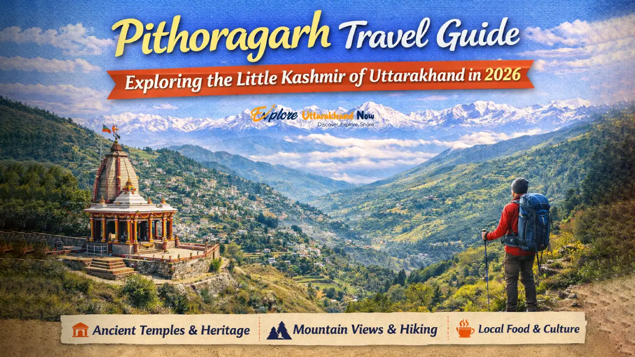
India’s most scientifically contested and spiritually charged trek — fully updated for legal compliance in 2026
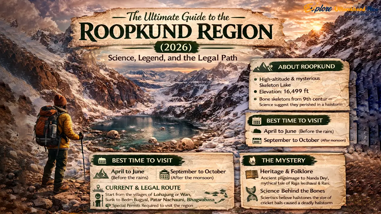
At 15,700 feet, there is a lake that should not exist. The glacial bowl of Roopkund fills and empties with the seasons, and when its waters recede in September, they reveal something that has baffled scientists, unsettled archaeologists, and confirmed every legend the Garhwali hill people ever told: hundreds of human skeletons, lying exposed on the rock and shingle as though they simply lay down to rest. But rest is not what happened here.
This is the definitive 2026 guide to the Roopkund region — one that respects both the science and the legend, explains the legal reality of trekking here today, and gives you the tools to do it responsibly. We have deliberately built this to replace every outdated, legally inaccurate, and ecologically irresponsible guide that still dominates search results. Read this, and then go — the right way.
— WHY THIS TREK —
Why Roopkund Remains the Everest of Indian Trekking
Beyond the Skeletons: High-Altitude Meadows and Glacial Mysteries
The skeletons are the headline, but they are not the whole story. The Roopkund trail is, by any measure, one of the most visually spectacular high-altitude routes in India. The approach through Ali and Bedni Bugyals — vast, undulating meadows at nearly 12,000 feet — offers panoramic views of the Trishul massif (7,120 m) and Nanda Ghunti (6,309 m) that arrive with the abruptness of a revelation. One moment you are in oak and rhododendron forest; the next, the hillside simply opens, and there is the entire western Kumaon Himalaya, ranged across the northern horizon like a sentence that ends in an exclamation mark.
Higher up, the terrain shifts again. The rock shelters at Bhagwabasa (14,100 ft) have an eerie, end-of-the-world quality — the stone is dark basalt and schist, the wind is constant, and the silence between gusts feels thick enough to touch. This is a place that demands your full physiological and psychological attention. The lake itself, when the snow and meltwater recede in late September and October to reveal the bones, is smaller than most people imagine — roughly 40 metres across — but carries the gravitational weight of a much larger monument.
The 2026 Perspective: Why Roopkund Is No Longer ‘Beginner-Friendly’
For years, commercial trekking companies marketed Roopkund as a ‘moderate’ or even ‘beginner’ trek. That categorisation was always optimistic; in 2026 it is simply inaccurate. The logistical changes introduced by the Uttarakhand government — specifically the elimination of meadow camping and the shift to village-based accommodation — have added distance, gained elevation, and required greater self-sufficiency from trekkers. This is now a demanding, multi-day high-altitude route that requires genuine physical preparation and a minimum of two or three prior Himalayan treks at 10,000+ feet.
If you are new to Himalayan trekking and are looking for a high-altitude introduction, we strongly recommend starting with the Chopta Tungnath Chandrashila Trek — it offers comparable panoramic rewards at 13,100 feet with a fraction of the logistical complexity. Come back to Roopkund when your lungs know what 14,000 feet feels like.
— LEGAL REALITY —
The 2026 Legal Status: Navigating the ‘Bugyal’ Ban
The High Court Ruling: A Transparent Look at the Camping Ban
In 2018, the Uttarakhand High Court issued a landmark ruling restricting overnight camping on the alpine meadows — bugyals — of the state, specifically citing Ali Bugyal and Bedni Bugyal in the Roopkund region. The ruling was not a ban on trekking; it was a ban on camping on the grass itself. The ecological rationale was clear: decades of commercial trekking had degraded the fragile, soil-thin turf of these meadows through tent pegs, open fires, and human waste. The bugyals are among the most ecologically sensitive grassland ecosystems in the Indian Himalaya, and they were being destroyed.
Legal Status (2026): Trekking through Ali and Bedni Bugyals is fully permitted during the open season (approximately May–June and September–November).
What is banned: Overnight camping on the meadow grass. Pitching tents on the bugyal turf, open fires, and unmanaged waste disposal.
What is legal: Day hiking across the meadows, trekking through them en route to higher destinations, and staying in designated forest-fringe campsites at the edges of the meadows.
How We Trek Today: Village Homestays and Forest-Fringe Campsites
The practical result of the ban is that the modern Roopkund trek is more culturally rich and logistically honest than its pre-ban incarnation. Trekkers now base themselves in Didna village (on the approach) and Wan village (on the descent) — two Garhwali communities at the edge of the forest that have developed a genuine homestay culture over the past four years. Meals are Garhwali home cooking: thick rotis, dal with mountain herbs, seasonal sabzis, and a glass of warm milk from cattle whose grazing range extends to 10,000 feet. This is not a compromise; it is a fundamentally better experience than sleeping in a commercial tent city on the meadow.
Permits & Forest Department Rules: The 2026 Digital System
As of 2026, all Roopkund trekkers are required to register through the Uttarakhand Forest Department’s online portal before commencing the trek. The permit counter is physically located at Lohajung basecamp, but completing the digital registration in advance is strongly recommended to avoid queues. Key details:
- Entry fee: ₹150 per person per day (Indian nationals); ₹600 per person per day (foreign nationals)
- Group size: Maximum 20 trekkers per registered group
- Mandatory: Proof of identity, emergency contact details, fitness self-declaration
- Seasonal window: The forest gate is typically open May 1 – June 15 and September 1 – November 15, subject to weather. Check the Chamoli District Forest Division website for real-time gate status before travel.
⚠ IMPORTANT NOTE
Permits cannot be purchased retroactively. Trekkers caught beyond the forest gate without a valid digital permit face fines of ₹2,500–₹10,000 and potential trail bans. Register before you arrive at Lohajung.
— THE SCIENCE —
Solving the Mystery: The 2019 Science Update vs. Local Lore
The DNA Breakthrough: The End of the Single-Catastrophe Theory
For decades, the dominant explanation for the Roopkund skeletons was a single catastrophic event — typically framed as a sudden hailstorm around 850 CE that killed an entire pilgrim group crossing the high pass. The story was clean, dramatic, and wrong.
In September 2019, a landmark paper published in Nature Communications by an international team including researchers from Harvard, CSIR-CCMB Hyderabad, and the Max Planck Institute, delivered what the scientific community calls a paradigm shift. Using advanced genomic sequencing of 38 skeletal samples, the team identified not one group, but three genetically distinct populations:
THE NATURE COMMUNICATIONS FINDINGS (2019)
Group 1 — South Asian ancestry (23 individuals): Died approximately 800 CE. Most likely pilgrims from across the Indian subcontinent making the Nanda Devi Raj Jat circuit. Consistent with the original hailstorm/single-event hypothesis.
Group 2 — Eastern Mediterranean ancestry (14 individuals, genetically closest to modern populations of Greece and Crete): Died approximately 1800 CE — nearly a millennium after Group 1. This is the discovery that broke the single-catastrophe theory. No historical record explains why a group of Mediterranean individuals died at 15,700 feet in the Kumaon Himalaya in the 19th century.
Group 3 — Southeast Asian ancestry (1 individual): Also died approximately 1800 CE. Possibly an outlier traveller, soldier, or trader along the trans-Himalayan route network.
The critical implication: Roopkund was not the site of one mass death. It has been visited — and died upon — by multiple distinct human groups across more than a thousand years of history.
The Mediterranean finding, in particular, has generated intense academic debate. Were these individuals part of a British colonial-era survey team with Mediterranean employees? Pilgrims from the Orthodox Christian tradition attempting an obscure high-altitude journey? Soldiers caught in a freak weather event? As of 2026, no consensus explanation exists.
The Myth of the Hailstorm: Comparing Science with the Goddess’s Curse
The local Garhwali oral tradition, maintained by the communities of Wan and Lohajung for generations, tells a different story. According to legend, Goddess Nanda Devi — the patron deity of Uttarakhand and the spiritual axis of this entire region — was conducting the sacred Raj Jat yatra with her divine retinue. A group of mortal pilgrims, guilty of arrogance and ritual impurity, followed the procession onto the high passes. The Goddess’s guardian, Latu Devta, unleashed iron hailstones upon them as divine punishment. Their bones remain as a permanent warning.
What makes this legend scientifically interesting is that the original Group 1 findings — South Asian pilgrims dying around 800 CE with signs of fatal blunt-force trauma to the skull consistent with large hailstones — do not contradict the legend. They partially validate it. The hailstorm explanation almost certainly applies to at least one of the three populations. The science and the legend are not opposites; they are looking at different pieces of the same extraordinarily complex human story.
The Nanda Devi Raj Jat Connection: The Sacred Home of the Goddess
Understanding why people have been dying at Roopkund for over a thousand years requires understanding the Nanda Devi Raj Jat — a sacred procession that occurs every twelve years and is considered one of the most important religious events in the Garhwal and Kumaon Himalaya. The yatra covers 280 kilometres through high mountain terrain, tracing a circuit that passes through the Roopkund region and culminates at the Roopkund lake itself, considered the earthly throne of Nanda Devi.
For the communities of Wan, Sutol, and Lohajung, this is not history or mythology — it is living geography. The mountains here have names, personalities, and divine authority. The Trishul peak is not merely 7,120 metres of rock and ice; it is the weapon of the Goddess. Trekking here without understanding this context is like visiting the Colosseum and thinking it is just a stadium.
— THE ROUTE —
The 2026 ‘Legal’ Itinerary: A Compliant 6-Day Route
| Day | Stage | Duration | Stay | Altitude |
| Day 1 | Rishikesh / Haridwar → Lohajung | 8–10 hrs drive | Guesthouse/hotel in Lohajung | ~7,500 ft |
| Day 2 | Lohajung → Didna Village | 5–6 hrs trek (9 km) | Homestay in Didna | ~8,700 ft |
| Day 3 | Didna → Ali Bugyal (day hike) → return | 6–7 hrs round trip | Homestay in Didna | ~11,900 ft (high point) |
| Day 4 | Didna → Patar Nachauni → Bhagwabasa | 7–8 hrs trek | Rock-shelter / fixed camp | ~14,100 ft |
| Day 5 | Bhagwabasa → Roopkund → descent to camp | 5–6 hrs summit push | Rock-shelter / fixed camp | ~15,700 ft |
| Day 6 | Bhagwabasa → Wan Village → Lohajung | 7–8 hrs descent | Depart or overnight Lohajung | ~6,800 ft |
Day 1–2: Arrival in Lohajung and the Move to Didna Village
Lohajung (7,500 ft) is the logistical heart of the Roopkund trek — a small ridge-top town in Chamoli district where you register permits, hire porters, and sleep off the road journey before the real work begins. Do not underestimate the approach drive; the road from Rishikesh is approximately eight hours of mountain switchbacks and the cumulative fatigue is real. Spend your first evening doing nothing strenuous. The following morning, the trail to Didna village (8,700 ft) winds through oak and mixed forest — a genuinely pleasant 9-kilometre walk that serves as your body’s first honest test of the altitude ahead.
Day 3: The Push to Ali Bugyal and Return
This is the day that justifies the entire trip for many trekkers, even those who never reach the lake. The climb from Didna to Ali Bugyal (11,900 ft) passes through the last dense forest before the treeline breaks open onto the meadow. The view that greets you — Trishul’s triangular ice face filling the northwest sky, the emerald-green bugyal rolling away at your feet — is a photographic event that requires no filter and very little skill. Under the 2026 permit rules, you return to your Didna homestay for the night rather than camping on the grass. This is not a hardship; the walk down through the evening light is beautiful in its own right, and a hot Garhwali dinner awaits.
Day 4–5: Reaching Bhagwabasa and the Summit Push
The climb from Didna through Patar Nachauni to Bhagwabasa (14,100 ft) is the section that sorts serious trekkers from wishful ones. The altitude gain is significant, the terrain above the treeline is exposed to weather, and the rock shelters at Bhagwabasa are exactly as austere as they sound — natural overhangs improved minimally by dry-stone walls, with sleeping platforms that require a good mat and a good sleeping bag. This is where the Himalaya stops pretending to be hospitable.
The summit push to Roopkund Lake (15,700 ft) requires an early start (3:30–4:00 a.m.) to clear the final ice and snow approach before afternoon weather deteriorates. The lake, when you reach it, is exactly as the legends describe and exactly as the scientists found it: small, dark, and surrounded by ancient bone. The combination of extreme altitude, thin air, and the actual physical presence of centuries-old human remains produces a genuinely unrepeatable psychological experience.
Day 6: Descent via Wan Village
Most trekkers descend the alternate route via Wan village (6,800 ft), a traditional Garhwali settlement that offers a completely different cultural experience from Didna. Wan’s temple complex and its connections to the Nanda Devi tradition make it worth slowing down for, even when tired legs want to keep moving. From Wan, vehicles return to Lohajung for the onward journey.
If you find this route too demanding or are planning a future trip with lower fitness, our guide to the Best Treks of Uttarakhand covers a full range of alternatives across every difficulty level.
— ALTERNATIVE ROUTE —
The Ali Bedni Bugyal Alternative: The ‘Meadow King’ Trek
Why Many 2026 Trekkers Are Stopping at the Meadows
There is a growing and entirely reasonable school of thought that says the meadows are the destination — and that the lake, while extraordinary, is a bonus that requires a level of fitness and risk tolerance that not everyone should attempt in a single trip. Ali and Bedni Bugyals at nearly 12,000 feet offer one of the finest high-altitude meadow experiences in India, with the full Trishul–Nanda Ghunti panorama, zero crowds (by Himalayan standards), and the ecological comfort of knowing you are trekking with essentially zero footprint on the fragile terrain above.
Photographers’ Paradise: Trishul and Nanda Ghunti Without Extreme Altitude
The photography at Ali Bugyal operates on a logic that professional mountain photographers understand well: proximity to the peaks does not always produce the best images. From the bugyal, you are at the perfect focal distance from Trishul’s 7,120-metre face — close enough for the ice seracs to be individually visible, far enough for the entire mountain to fill a wide-angle frame. The foreground of green meadow, wildflowers (June) or russet autumn grass (October), and occasional grazing cattle creates the compositional layering that distinguishes great mountain photography from mere documentation.
High Reward, Moderate Effort: The Accessible Alternative
The Ali Bedni Bugyal circuit is, in structure and reward-to-effort ratio, comparable to the Chopta Tungnath Chandrashila Trek — a well-regarded high-altitude day-accessible route. Both offer panoramic Himalayan views above 11,000 feet, both involve manageable trekking distances, and both are ecologically sensitive areas where responsible trekking practice is non-negotiable. The bugyal trek can be completed comfortably in 3–4 days using the Didna homestay as a base.
— PREPARATION —
Physical & Gear Prep for 16,000 ft: The Technical Guide
The Oximeter Protocol: Knowing Your SpO2 at Bhagwabasa
A pulse oximeter is not an optional luxury on the Roopkund trek — it is essential diagnostic equipment. At Bhagwabasa (14,100 ft), a healthy acclimatised trekker should register SpO2 readings of 85–92%. Below 80%, the standard protocol is immediate descent. Below 75%, descent is non-negotiable and potentially life-saving. Buy a reliable finger oximeter before you leave (Contec or Beurer are trusted brands available in India for ₹800–1,500). Check your readings three times daily — morning, afternoon, and before sleep. Log them. Compare them. Trust them over how you feel.
⚕ PRO-TIP: AMS RECOGNITION & RESPONSE
Acute Mountain Sickness (AMS) is common above 10,000 ft and can progress to High Altitude Pulmonary Edema (HAPE) — a potentially fatal condition — within hours.
Early AMS symptoms: headache, nausea, fatigue, loss of appetite, poor sleep. These are normal at altitude. Watch them; do not dismiss them.
Red flags requiring immediate descent: confusion or disorientation, inability to walk in a straight line, persistent dry cough with frothy or pink sputum (HAPE warning sign), SpO2 below 80%.
The 2026 standard: All commercial and independent trekkers above 12,000 ft in Uttarakhand are now expected to carry a basic AMS kit: Diamox (acetazolamide, by prescription), Dexamethasone (emergency use, by prescription), and a portable pulse oximeter.
The Buffer Day rule: Build one full acclimatisation rest day at Bhagwabasa before the summit push. This is no longer optional best practice — it is the safety standard recommended by the Wilderness Medical Society and increasingly mandated by registered Uttarakhand guide associations.
2026 Gear List: Layers, Gore-Tex, and Eco-Conscious Choices
The temperature range on the Roopkund trek — from 18°C in Lohajung to as low as -10°C at Bhagwabasa on a clear October night — demands a complete layering system. Here is the 2026 gear list with notes on sustainable alternatives:
- Base layer: Merino wool (Icebreaker, local Kullu-Manali handspun wool) — superior to synthetic for multi-day use, naturally odour-resistant
- Mid layer: Recycled-PET fleece jacket (Patagonia Synchilla or Indian equivalent from Wildcraft’s recycled range) — insulation without virgin petroleum
- Outer shell: Gore-Tex or eVent hardshell jacket — non-negotiable above 12,000 ft where weather turns without warning
- Insulation layer: 700-fill down jacket or synthetic equivalent (Primaloft) for Bhagwabasa evenings and the pre-dawn summit push
- Boots: Waterproof leather or synthetic high-ankle trekking boots with Vibram sole — broken in before the trek, never on the trek
- Trekking poles: Carbon or aluminium — essential for descent from Bhagwabasa on loose scree and potential ice
- Sleep system: Sleeping bag rated to -10°C minimum (comfort rating, not limit rating). Hemp-fill bags from Indian artisan manufacturers are now available as an eco-conscious alternative
- Water: 2-litre insulated bottle + Sawyer Squeeze or SteriPen UV purifier — refuse all single-use plastic bottles above Lohajung
For a detailed comparison of technical gear requirements at this altitude versus the demanding but differently challenging Sahastra Tal Trek — another remote high-altitude lake route in Uttarakhand — note that Sahastra Tal’s greater remoteness (8–10 days, no fixed infrastructure) requires even more self-sufficient gear setup, particularly for waste management and water treatment.
— RESPONSIBLE TREKKING —
Responsible Trekking: Supporting the Local Economy
Beyond Commercial Tents: The ‘Lohajung Economy’
The Roopkund region’s transition from commercial tent-city trekking to village-based tourism is not merely a legal compliance exercise — it is an economic transformation with genuine community impact. The families of Didna and Wan who operate homestays earn significantly more per trekker than they did as peripheral suppliers to commercial trekking companies. Local porters (predominantly from Wan, Sutol, and Lohajung communities) who previously earned piece-rates from agencies now negotiate directly with trekking groups, retaining a far higher share of the value they create.
The practical instruction for 2026 trekkers is simple: book your homestays and hire your porters directly through Lohajung-based operators rather than through large city agencies. The Roopkund Trek Cooperative (registered 2022) maintains a roster of certified local guides and porters with standardised day rates (₹800–1,200 per day for porters; ₹1,500–2,000 per day for guides). Ask for the register at the Lohajung permit office.
Leave No Trace (LNT) 2.0: Managing Waste in the High Himalaya
Standard LNT principles apply everywhere on this trek. But at 14,000+ feet, two issues require specific attention:
Human waste management: Above the treeline, there are no natural decomposition systems for human waste. All trekkers are required to carry waste disposal bags (available at the Lohajung permit counter) and use designated waste pits at fixed campsites. Do not bury waste in the high alpine zone — it does not decompose and contaminates water sources.
Plastic: The single most effective thing you can do for the Roopkund ecosystem is to carry every piece of plastic waste you generate back to Lohajung. The mountain does not have a waste management system. You are it. This includes chocolate wrappers, energy bar packaging, tea bags, and any other non-biodegradable material.
Cultural Etiquette: Respecting Wan Village
Wan is an ancient settlement with deep connections to the Nanda Devi tradition. Several practical etiquette points for visiting trekkers:
- The village temple is an active worship site, not a photo opportunity. Ask permission before photographing religious spaces or rituals.
- Remove footwear before entering any homestay or religious building.
- The correct greeting is “Jai Nanda Devi” — acknowledge it if offered and feel free to use it yourself.
- Alcohol is not prohibited, but drinking publicly in the village is considered deeply disrespectful. Drink in your accommodation, not on the street.
- Pay the agreed rate for homestays and porter services. Do not negotiate down; these are already modest rates for significant physical and logistical labour.
— FAQ —
Frequently Asked Questions (2026 Edition)
Is the Roopkund Trek Currently Open for Tourists?
As of March 2026, the Roopkund trail is open for the upcoming season (May 1 – June 15 and September 1 – November 15, subject to weather and government orders). The forest gate status can change due to extreme weather events, landslides, or policy revisions. Always verify the current gate status with the Chamoli District Forest Division office (contact available on the Uttarakhand forest department website) within one week of your planned departure. Do not rely on travel agency websites or social media posts as authoritative sources for gate status.
How Does the Difficulty Compare to the Har Ki Doon Trek?
Roopkund is considerably more demanding than Har Ki Doon. Har Ki Doon (maximum altitude ~11,600 ft) is a well-established moderate trek with reliable infrastructure, regular trail maintenance, and no significant technical terrain. Roopkund (15,700 ft) involves nearly 4,000 additional feet of altitude gain, more remote terrain, greater weather exposure, and — post-ban — fewer infrastructure supports at high camp. If you have not completed Har Ki Doon or an equivalent, complete it first. The comparison table below shows the key differences at a glance:
| Trek | Duration | Difficulty | Max Alt. | Accommodation |
| Roopkund Trek | 7–9 days | Difficult | ~15,700 ft | Village homestays + fixed camps |
| Har Ki Doon Trek | 6–7 days | Moderate | ~11,600 ft | Campsites + PWD rest houses |
| Chopta–Tungnath–Chandrashila | 3–4 days | Easy–Moderate | ~13,100 ft | Hotels + basic camps |
| Sahastra Tal Trek | 8–10 days | Difficult | ~14,900 ft | Remote campsites |
| Ali Bedni Bugyal (only) | 3–4 days | Moderate | ~11,900 ft | Didna homestay + fringe camp |
Can I See the Skeletons in October? (The Snow Cover Debate)
This is the most practically important question most visitors ask, and the answer requires nuance. The skeletons are visible at the lake surface when water levels are low and snow cover is minimal — conditions that typically occur in late September to mid-October, after the monsoon rains have receded but before the first heavy snowfall of the winter season. Earlier in the year (May–June), the lake is often still partially frozen or covered in compacted snow, and the bones are largely obscured. The optimal window for skeleton visibility — which many visitors understandably prioritise — is October 1–20, weather dependent. After mid-October, early winter snowfall can cover the lake and trail entirely. Check snow reports from the Lohajung guesthouses and the forest gate team before your final approach to Bhagwabasa.
— CONCLUSION —
Conclusion: The Legend Lives On
The bones at Roopkund are not going anywhere. They have outlasted the empires and civilisations that produced the people who died here — South Asian pilgrims in the 9th century, Mediterranean travellers in the 19th century, one solitary individual from Southeast Asia whose story we may never know. The lake holds them all with perfect democratic indifference.
What the 2019 genomic study gave us is not closure — it gave us more questions, more wonder, and a much more honest admission that this place is genuinely mysterious in ways that neither science nor legend has fully explained. The Goddess’s curse and the DNA lab are not competing for the same territory. They are looking at the same extraordinary fact — that human beings have been dying here for over a thousand years — and finding different types of meaning in it.
The trek to Roopkund in 2026 is harder and more honest than it used to be. You sleep in Garhwali homes rather than commercial tents. You hire local guides rather than city agencies. You carry your waste back with you. And in exchange for this extra effort and responsibility, you get something the commercial era rarely offered: a genuine relationship with one of the most remarkable landscapes and communities in the Indian Himalaya.
The Question We’ll Leave You With
When you finally stand at the edge of Roopkund and look at the skeletons in the shallow water — do you see a scientific dataset of three genomically distinct populations separated by a thousand years, or do you see the iron hailstones of an angry Goddess? And does it matter which answer feels more true?
Tell us in the comments below.